Cutter's Log - Stardate 1102.70.80
Current Song - That Girl (Stevie Wonder)
There is this Facebook group called "You Know You Grew up in Sterling/Rock Falls If......" which has recieved lots and lots of posts and new members in the past couple of days. Something that could literally slow down Facebook data transfer.
I started posting on it yesterday. About 75% of the memories are of places that either are not around anymore, or I remember and are not around anymore. There are not that many people in the group, which now has over 2,000 members, that are my age. I can only think of one right at my age, and a few just a few years older than I am. So the seven of us have memories that can't really be duplicated by the other couple of thousand or so.
I have lived in Sterling and Rock Falls all of my 25 years on this Earth, and never moved out. This is something that I'm actually proud of. I didn't take the easy way out, by taking the first train out of town right after high school commencement - like several of my classmates have. My first house was an upstairs apartment across the alley from the former Young's Bakery (another store in RF lore). We then moved to a yellow house on East 11th Street in Sterling (on the same block as the Synagogue). Then back to 3rd Avenue in Rock Falls, and then to my present location at 17th Avenue in Sterling - where I've been for the past 14 years. I've been to six schools in a span of 10 years.
Many people "back then" truthfully looked at Sterling and Rock Falls as two seperate cities. Sterling people had little memories of Rock Falls, and vice-versa. Since I spent time in both towns, I look at the whole area as a giant town. This is something that, in a good 20 years, others growing up after me will see. We grew up after the football cease-fire of 1994. Then the two schools became divided even more with the athletic conference setups, which happened after I left high school. I think students from both sides of the river have been getting along more and more.
Currently, there is debate over what to do with the riverfronts of both towns. Those that are making the decisions (the older people) have grown up back in a time when the two towns were "seperate" and wanted nothing to do with each other. Put these decisions in the hands of the current 20- or 30-somethings and perhaps we can come up with an agreement as to how to make this happen. Most of the holdup is over filtering out which city gets what.
Why is there bitterness? My personal story, which I have written on here many times, is unique and not equal to others. However, this is what I can only guess: When we were young, the thought of "hating" the city on the other side of the river did not exist. In other words, it was not born with us. Perhaps it was the parents (both of whom went to the school that their child will have went to) that began to instill this rivalry in them. If it was not the parents, it certainly had to be the high school athletic coaches. I think the backlash over Sterling losing to Rock Falls was far greater than Rock Falls losing to Sterling.
When our economy started to turn bad, with the downfall of NWSW, I think the two cities began to utilize one another more. The kids in my generation began hanging out together. Such things like ICQ, MSN Messenger, MySpace and Facebook really started to bridge the gaps between us DURING high school, and not 15 years afterward. We would interact more within little league baseball and softball. This is the future of the Sterling/Rock Falls area, and with apologies to those 20 years older than me, this is what it's gonna be.
Indeed, the economic downturn has caused a lot of the places mentioned in the S/RF Facebook Group to shutter. As for my generation, we have very little memories of these things.
Before I go on any further, what do I mean by "my generation"? Three years either way of myself: high school graduation classes of 2001-2008. In other words, you graduated from high school during the George W. Bush presidency. In talking with people from my generation, early memory retention doesn't seem to be all that great. Mine, however, is great and has been called so by my peers.
What do we remember of Sterling/Rock Falls prior to 1994? We will be the last generation to remember ...
*Emil's, Eberley's, George Furniture, when KFC was downtown, the Lincoln Tavern and the Kastle. But we remember them more for being destroyed.
*(Not early history, but worth noting) My high school graduating class (2005) was the last to remember the head coaching tenure of Coach Gaumer, before Coach King came in and ushered in the current feel of Sterling HS football we know today. When I graduated, I was the last remnant of the 4-5 varsity team that was outscored 99-0 our final two games of the season. Our logo during our freshman year was actually a warrior head, and not a dreamcatcher with an "S" on it.
*When Route 40 was Route 88.
*The Merrill students of my generation will be the last to remember Lois Dady teaching music, and Ludy Eddinger as a strict substitute teacher. And when the lot where a parking lot is now was big enough for a soccer game (K-2 had lunch recess on the north playground, and 3-5 was on the south playground).
*The flood of 1993 on the Rock River, the last time the river got that high. I still remember driving in my parent's '78 Buick down to the Lower Dam to look at the damage.
*Safety Park, which they tore away in the early-to-mid 90s I believe.
*The International Harvester fire of 1993, a slightly smaller version of the 2004 Mill fire that most of us do remember.
*White Hen Pantry on Locust in Sterling and First Avenue in Rock Falls. Back when they were actually called White Hen. When it was an 8th grade hangout for my graduating class, we still called it White Hen.
*What Ken Nelson looked like. His face and white hair was on the local TV commercials up until around that point.
*When they were called A&W's, and not Big Bopper's. There was still car delivery at that time, where we had to push a red button from our cars to deliver our order.
*When Kilgour Park was nothing more than an open field with hoops and a tennis court.
*The old Dairy Queen on the west side of Sterling, before they rebuilt it. Walked there on a preschool fieldtrip.
*When Supervalue was on its tail end, prompting the call for a new west side supermarket. The end result was County Market.
*Running on the orange grocery bagging shelves at the old Aldi's!!
*What Avenue G bridge looked like before it was rebuilt, it had the thin rails. My mom once said there were many holes on that bridge that looked down toward the river.
*The Glafka's Tire City jingle that sounded like the old MoTown song "The Boy from New York City"
*When circuses were on the empty lot where the Randolph Hotel once stood (West 3rd and Avenue A).
*Jerry Warren's dealership next to the Coliseum.
*Video Discount and Sam Metzler Realty ... Sam is my great-granduncle.
*When that building on the NW corner of East 4th and 12th Avenue in Sterling was actually occupied.
*When there wasn't a stop sign at the intersection of East 5th Street and 13th Avenue in Sterling, next to the Nazerene Church.
*When East End Shell was a few blocks to the west of where it is now, and Billy used to work there.
*Sterling Furniture, Sears (with the dark blue lettering), Realty World, Carpet World, Stars and Stripes Video, Pelican Restaurant, Rax, Ken Nelson by the mall and Wolohan Lumber were on the Eastern business district. And the two farthest places out where the Builder's Discount and Farm and Fleet. And there was no stoplight at 2 and Polo Road.
*Kid Zone! Camelot Music, Woolworth's and its restaurant, Walgreen's, Stuarts, KayBee Toys, the ice cream place whose name I can't recall, and the yellow-colored penny deposit where it whirled like a tornado -- all of which were at Northland Mall. (More people younger than me will remember Blackhawk Arcade and Diamond Dave's).
*The aforementioned Young's Bakery in Rock Falls, corner of West 2nd and 3rd Avenue.
*A Citgo sign and a Sunoco sign at the corner of 1st Avenue and Dixon Avenue in Rock Falls.
*Dairy Dreem, where Adami Insurance is now!
*There was a small dirt path behind the Rock Falls Eagle food store, accessible from the end of Stanley Court and going toward West 10th Street. And how real bad that trail smelled!!
*The Igloo for ice cream and Honky's for ribs in the new Centennial Plaza in Rock Falls. We had Honky's for lunch as we were packing and moving back to Sterling from Rock Falls 14 years ago.
*The black and white Central National Bank logo, with the capital "C" on top of the "NB".
*We called Rheeling's "IGA" because that was the logo we as kids could recognize. That was the last of the true neighborhood supermarkets in Rock Falls. 5th Street Mini Mart was the last of the true neighborhood supermarkets in Sterling, and we could remember that, too. It had a Pepsi logo on top of the sign.
*Dr. Provow's and Dr. Lipinski's office (as well as others) on Dixon Avenue before it was torn down due to roof damage.
*Figuring out our bowling scores using a pencil and paper, while youth bowling on Saturday morning's at Rocket Lanes. Tony Deroste, Larry Thompson, and a guy named Jim were the guys that coordinated the bowling back then.
*Red Carpet Video on Route 30, before Video Village expanded and forced it out of business.
and that's all I can think of right now.
Sunday, August 7, 2011

Friday, August 5, 2011
"Me" Party
Cutter's Log - Stardate 1102.50.80
Current Song - Too Much Heaven (Bee Gees)
I never really liked this group they call the "Tea Party." They're just too far to the right of the politcal spectrum, you know, the Rush Limbaugh side of the chart. Then again, my line of thinking has always been far left. Taking a few Government surveys in high school solidified my position.
My hatred for these teabaggers got worse after reading an article in Friday's SVM regarding the fact that the local Tea Party group demanded that Republican congressman Bobby Schilling (who represents where I live) explain the reason why he voted for this debt ceiling compromise.
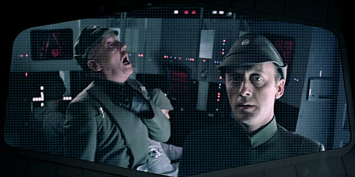
I do not believe we elected the local Teepee chair as our congresswoman. This kind of news makes me think of a scene (pictured above) from The Empire Strikes Back: When the Admiral of Vader's flagship goes out of hyperspace too early and is force-choked to death by Vader.
"YOU are now in command, Congressman Piett."
I sense a theme.
Or maybe more like this ...

"Apology accepted, Congressman Needa."
Tuesday, August 2, 2011
Money Thoughts
Cutter's Log - Stardate 1102.20.80
Current Song - Badge (Cream)
So I'm going over my personal books lately. I didn't do much during the summer, which is a monetary gain of sorts. As of right now I'm preparing for the August costs of the prep sports season.
Among something I need is a digital camera of my own. For the past couple of years I have been borrowing Dan's camera. I'm sure when I'm using it at places, he would have liked to use it for his things. So that's something I'm saving up for. The sports-quality cameras run at just over a hundred dollars. At putting aside 10 dollars a week, it'll be toward the end of the regular football season until I finally get one of my own. Until then, Dan has let me borrow the camera.
If the video process works out well for the website, it won't be long until I'll be needing a second battery to ensure even more video possibilities.
In order to do all of this, I'll have to remain "bare bones," which I think I can do.
ADDITION - 8/4
I have noticed that I've become more energetic than I used to be. I can't quite grasp why, but I think it has to do with getting a haircut. Seems weird, huh?
With this haircut, I have also begun to shave my facial hair more often than I used to. In addition, at work I have to crouch down to the floor to retrieve loose change that I accidentally drop - that used to be a pain, and now that is not a problem. So perhaps I've dropped a few pounds? A few is better than zero.
So what does this have to do with money? I'm thinking about bringing the bicycle back from the abyss that is the garage. Hopefully it will still work well. I think I shelved it due to severe butt pain, even with the gel-padded seat. Using the car more for longer trips could possibly save on oil changes along with the fuel. I don't know, but I think it's worth trying. I want to try to ride to Sterling, Rock Falls and Newman games with the bike as much as I can, in addition to work and errands.
There was a message board weight loss contest that had the slogan "Do More, Eat Less." I feel like "Do More, Earn More, Eat Less, Spend Less."
More Ideas:
*When I do make a trip to a game, I'll have to find a way to have a light dinner along the way back home. Emphasis on the word LIGHT.
*Buy water instead of pop. I will also be utilizing a totebag for all my reporting accessories (and thus retiring the Rock Falls Rockets bag I had been carrying around for years), and there is room for bottled water. A small cha-ching, but considering the number of games covered this is a pretty good idea.
*Make like insurance companies and BUNDLE. Sometimes I would go on far-away errands on days that I didn't have a game to cover. Rather than do that, I think it's easier to bundle things into one trip. For example, I am looking at a new digital camera. If I am interested in one at Best Buy, rather than going to Rockford or Moline and back I'll combine that with a game to cover around there. That being said, I have at least one trip to Rockford and one to Aurora both in August.
*Take my time getting to these places. It is believed that the faster you go, the more gas you are wasting. Most days that I cover a game, I'm not working. I have time to get to the games. But at the same time, I can't go super slow.
**Finally, I think it's important to point out that I'm not in a financial crisis or anything. From the looks of the things that I've written, it seems more like the "Tea Party" and its idea of spending cuts. If you know me, I'm far from these tea baggers. The difference here is that I am not in a financial crisis.
I have money. I have a job, and I like it. But when you cut spending it makes it seem as if you have more money in your name. And more money in your name, well, is really good for you.
Current Song - Badge (Cream)
So I'm going over my personal books lately. I didn't do much during the summer, which is a monetary gain of sorts. As of right now I'm preparing for the August costs of the prep sports season.
Among something I need is a digital camera of my own. For the past couple of years I have been borrowing Dan's camera. I'm sure when I'm using it at places, he would have liked to use it for his things. So that's something I'm saving up for. The sports-quality cameras run at just over a hundred dollars. At putting aside 10 dollars a week, it'll be toward the end of the regular football season until I finally get one of my own. Until then, Dan has let me borrow the camera.
If the video process works out well for the website, it won't be long until I'll be needing a second battery to ensure even more video possibilities.
In order to do all of this, I'll have to remain "bare bones," which I think I can do.
ADDITION - 8/4
I have noticed that I've become more energetic than I used to be. I can't quite grasp why, but I think it has to do with getting a haircut. Seems weird, huh?
With this haircut, I have also begun to shave my facial hair more often than I used to. In addition, at work I have to crouch down to the floor to retrieve loose change that I accidentally drop - that used to be a pain, and now that is not a problem. So perhaps I've dropped a few pounds? A few is better than zero.
So what does this have to do with money? I'm thinking about bringing the bicycle back from the abyss that is the garage. Hopefully it will still work well. I think I shelved it due to severe butt pain, even with the gel-padded seat. Using the car more for longer trips could possibly save on oil changes along with the fuel. I don't know, but I think it's worth trying. I want to try to ride to Sterling, Rock Falls and Newman games with the bike as much as I can, in addition to work and errands.
There was a message board weight loss contest that had the slogan "Do More, Eat Less." I feel like "Do More, Earn More, Eat Less, Spend Less."
More Ideas:
*When I do make a trip to a game, I'll have to find a way to have a light dinner along the way back home. Emphasis on the word LIGHT.
*Buy water instead of pop. I will also be utilizing a totebag for all my reporting accessories (and thus retiring the Rock Falls Rockets bag I had been carrying around for years), and there is room for bottled water. A small cha-ching, but considering the number of games covered this is a pretty good idea.
*Make like insurance companies and BUNDLE. Sometimes I would go on far-away errands on days that I didn't have a game to cover. Rather than do that, I think it's easier to bundle things into one trip. For example, I am looking at a new digital camera. If I am interested in one at Best Buy, rather than going to Rockford or Moline and back I'll combine that with a game to cover around there. That being said, I have at least one trip to Rockford and one to Aurora both in August.
*Take my time getting to these places. It is believed that the faster you go, the more gas you are wasting. Most days that I cover a game, I'm not working. I have time to get to the games. But at the same time, I can't go super slow.
**Finally, I think it's important to point out that I'm not in a financial crisis or anything. From the looks of the things that I've written, it seems more like the "Tea Party" and its idea of spending cuts. If you know me, I'm far from these tea baggers. The difference here is that I am not in a financial crisis.
I have money. I have a job, and I like it. But when you cut spending it makes it seem as if you have more money in your name. And more money in your name, well, is really good for you.
Sunday, July 24, 2011
Some People You Just Can't Forget
It's been several years
And they have moved on
But they still linger
Two girls I loved
I loved them, loved them, loved them
They kept my feelings alive
When I was down, they were there
But only just in my mind
Away from me they are
Want no more of me
But I won't forget
Two girls I loved
And they have moved on
But they still linger
Two girls I loved
I loved them, loved them, loved them
They kept my feelings alive
When I was down, they were there
But only just in my mind
Away from me they are
Want no more of me
But I won't forget
Two girls I loved
Monday, July 18, 2011
Getting Back on Track
Cutter's Log - Stardate 1102.81.70
Current Song - Jazzman (Carole King)
After feeling down the past couple of days, I'm trying to work my way back up to feeling alright.
I decided to plan a drive along the county on Saturday morning. I figured it would keep me off of being worried somewhat. I looked at an 1872 county map and noticed all of the schools dotted. So I wanted to find these schools (if they were still up) and take pictures of them.
I think I have now been on every road in Whiteside County. I traveled the northern section before feeling tired from all of the driving. Most of what I found were either not there anymore, or fully converted into houses with additions to make them look unrecognizable. One near the flood plain near Fulton is now a little farm garage.
Probably the one that I was in awe of was one that lay in absolute ruins. It is on the corner of Capp and Lake Roads just north of Rockwood Park. The chimney is barely standing, and all the wood is piled on the ground and rotting. It lies in a bunch of overgrown weeds. I'm not sure what this school is called.
After telling my brother during dinner about what I was doing all of the morning, I got sick all of a sudden. It was bad enough where I couldn't sleep and was trying to fight it off.
The sickness necessitated only the second call-off from work in the three years I have been there. After perfect attendance in 2010, there will be no such honor for 2011. But I just couldn't work in the given condition. Even worse is the amount of money I DIDN'T make today. That's when it hits you. But I just couldn't work in it.
At this time (Monday, 1:30 a.m.) I feel alright. I go back to work at 5:00 p.m. When I get home, I'll probably start on getting the sleep cycle back on track.
Current Song - Jazzman (Carole King)
After feeling down the past couple of days, I'm trying to work my way back up to feeling alright.
I decided to plan a drive along the county on Saturday morning. I figured it would keep me off of being worried somewhat. I looked at an 1872 county map and noticed all of the schools dotted. So I wanted to find these schools (if they were still up) and take pictures of them.
I think I have now been on every road in Whiteside County. I traveled the northern section before feeling tired from all of the driving. Most of what I found were either not there anymore, or fully converted into houses with additions to make them look unrecognizable. One near the flood plain near Fulton is now a little farm garage.
Probably the one that I was in awe of was one that lay in absolute ruins. It is on the corner of Capp and Lake Roads just north of Rockwood Park. The chimney is barely standing, and all the wood is piled on the ground and rotting. It lies in a bunch of overgrown weeds. I'm not sure what this school is called.
After telling my brother during dinner about what I was doing all of the morning, I got sick all of a sudden. It was bad enough where I couldn't sleep and was trying to fight it off.
The sickness necessitated only the second call-off from work in the three years I have been there. After perfect attendance in 2010, there will be no such honor for 2011. But I just couldn't work in the given condition. Even worse is the amount of money I DIDN'T make today. That's when it hits you. But I just couldn't work in it.
At this time (Monday, 1:30 a.m.) I feel alright. I go back to work at 5:00 p.m. When I get home, I'll probably start on getting the sleep cycle back on track.
Friday, July 15, 2011
Where Did I Go Wrong?
Cutter's Log - Stardate 1102.51.70
Current Song - Spooky (Atlanta Rhythm Section)
I've been spending a great deal of time sitting in my computer chair in front of the computer. When I'm not staring at the screen, I'm staring into open space. Pondering about a few things related to why I'm at where I'm at today in regards to a certain aspect of life ... love.
Recently, it hit me that it has almost been 20 years since I first started realizing the whole difference between friendships between boys and girls. In other words, the first girl I "liked" was nearly 20 years ago.
Over the past 20 years, I estimated that I had crushes on at least 25 different girls. (No "Cutter Report" naming names is planned to come out).
I have come close twice toward establishing an official "going out" type of relationship. Once (7th grade) was the first - and to date the only time - I had the courage to ask a girl out (on a phone, of course). The other (freshman year) was something I wasn't quite ready for, and I kind of figured out it was nothing more than a diversion.
So I took some hours to think about my entire life history involving girls, and wondered where I went wrong. Why was I unable to establish such relationships? Why am I 25 years old and still unable to get a girlfriend?
***
Should I have not been a sissy and called a certain girl on the phone, especially when my best friend was pressuring me to do so?
Should I have completely abandoned the friendships I had established in Rock Falls before moving to Sterling for 5th grade? Did this possibly hinder efforts to have a very good 5th grade year?
Should I have been a little more kinder to that one girl who was "kind" to me? Furthermore, should I have completely ignored the slightest possibility that this was a diversion of sorts from the girl I actually liked?
Should I not have written my thoughts down in a little "coca-cola" book that was locked?
Should I have rode my bike elsewhere when I was feeling down?
Should I have done more than just sit there at the corner of the wall at recess time in middle school?
Should I have not written locker-hole notes to a certain girl?
Should I have not published a certain weekly rating list?
Should I have not tagged along behind the crowd, rather than just ignoring it?
Should I have not stuck up for a friend when a girl gave him a phony phone number (that I knew was phony after he revealed it to me)?
Should I have not found out who someone was without asking her first?
Should I have not made a fool of myself when trying out for the Talent Show?
Should I have just skipped that volleyball game out in the boondocks?
Should I have just been at peace with the fact that I just wasn't invited to a joint birthday party that it seemed like everyone else was invited to?
Should I have done more than bring her flowers?
Should I have learned slow dancing before actually doing it?
Should I have not made a (different) publication regarding jokes about a kid?
Should I have altered class-to-class paths?
(Now we hit high school)
Was that trip to Chicago for a softball game really worth it?
"Hody" (rhymes with butter)?
Should I have just stayed in Sterling?
Should I have just ignored SHS and followed RFHS all throughout high school?
Should I have made a move while managing? (On second thought, no, because it would have absolutely wrecked my life)
Should I have not played hookie?
Should I have known how to use ICQ before actually installing it?
Should I have done more than just ICQ chats and phone calls?
Should I have prepared for a certain meeting?
Should I have not gone on the legendary bike ride?
Should I have not made a cameo appearance at a certain place early in the morning?
Should I have made constant reminders about a "promise" that I would take somebody to prom? (Probably another diversion)
Should I have completely ignored a bus conversation between someone who told me he had a crush on someone?
Should I have seriously considered an offer to reside in an "extra bedroom" at someone's house?
Should I have kept my keypad untouched in a specific message board post?
Should I have asked that my assignments be a little more spread out than what they ended up being?
Should I have not quoted a certain someone out-of-order?
Should I have counted the number of championship rings a little more accurately?
Should I have stayed local during my senior year, rather than traveling all over creation to write game stories?
Should I have behaved a little better while driving back from a football game at Ottawa?
Should I have not tried out a photo angle from the floor?
(Now we hit college)
Should I have given more writing advice to certain people?
Should I have been a little more open in asking for help in a certain class?
(Now we hit the present time)
Should I be moving around a little bit more?
Current Song - Spooky (Atlanta Rhythm Section)
I've been spending a great deal of time sitting in my computer chair in front of the computer. When I'm not staring at the screen, I'm staring into open space. Pondering about a few things related to why I'm at where I'm at today in regards to a certain aspect of life ... love.
Recently, it hit me that it has almost been 20 years since I first started realizing the whole difference between friendships between boys and girls. In other words, the first girl I "liked" was nearly 20 years ago.
Over the past 20 years, I estimated that I had crushes on at least 25 different girls. (No "Cutter Report" naming names is planned to come out).
I have come close twice toward establishing an official "going out" type of relationship. Once (7th grade) was the first - and to date the only time - I had the courage to ask a girl out (on a phone, of course). The other (freshman year) was something I wasn't quite ready for, and I kind of figured out it was nothing more than a diversion.
So I took some hours to think about my entire life history involving girls, and wondered where I went wrong. Why was I unable to establish such relationships? Why am I 25 years old and still unable to get a girlfriend?
***
Should I have not been a sissy and called a certain girl on the phone, especially when my best friend was pressuring me to do so?
Should I have completely abandoned the friendships I had established in Rock Falls before moving to Sterling for 5th grade? Did this possibly hinder efforts to have a very good 5th grade year?
Should I have been a little more kinder to that one girl who was "kind" to me? Furthermore, should I have completely ignored the slightest possibility that this was a diversion of sorts from the girl I actually liked?
Should I not have written my thoughts down in a little "coca-cola" book that was locked?
Should I have rode my bike elsewhere when I was feeling down?
Should I have done more than just sit there at the corner of the wall at recess time in middle school?
Should I have not written locker-hole notes to a certain girl?
Should I have not published a certain weekly rating list?
Should I have not tagged along behind the crowd, rather than just ignoring it?
Should I have not stuck up for a friend when a girl gave him a phony phone number (that I knew was phony after he revealed it to me)?
Should I have not found out who someone was without asking her first?
Should I have not made a fool of myself when trying out for the Talent Show?
Should I have just skipped that volleyball game out in the boondocks?
Should I have just been at peace with the fact that I just wasn't invited to a joint birthday party that it seemed like everyone else was invited to?
Should I have done more than bring her flowers?
Should I have learned slow dancing before actually doing it?
Should I have not made a (different) publication regarding jokes about a kid?
Should I have altered class-to-class paths?
(Now we hit high school)
Was that trip to Chicago for a softball game really worth it?
"Hody" (rhymes with butter)?
Should I have just stayed in Sterling?
Should I have just ignored SHS and followed RFHS all throughout high school?
Should I have made a move while managing? (On second thought, no, because it would have absolutely wrecked my life)
Should I have not played hookie?
Should I have known how to use ICQ before actually installing it?
Should I have done more than just ICQ chats and phone calls?
Should I have prepared for a certain meeting?
Should I have not gone on the legendary bike ride?
Should I have not made a cameo appearance at a certain place early in the morning?
Should I have made constant reminders about a "promise" that I would take somebody to prom? (Probably another diversion)
Should I have completely ignored a bus conversation between someone who told me he had a crush on someone?
Should I have seriously considered an offer to reside in an "extra bedroom" at someone's house?
Should I have kept my keypad untouched in a specific message board post?
Should I have asked that my assignments be a little more spread out than what they ended up being?
Should I have not quoted a certain someone out-of-order?
Should I have counted the number of championship rings a little more accurately?
Should I have stayed local during my senior year, rather than traveling all over creation to write game stories?
Should I have behaved a little better while driving back from a football game at Ottawa?
Should I have not tried out a photo angle from the floor?
(Now we hit college)
Should I have given more writing advice to certain people?
Should I have been a little more open in asking for help in a certain class?
(Now we hit the present time)
Should I be moving around a little bit more?
Thursday, July 7, 2011
Can't Sleep
Cutter's Log - Stardate 1102.70.70
Current Song - Sign Your Name (Terence Trent D'Arby)
It's become apparent to me that I can't sleep at night without something reminding me about the unsuccessful attempts at figuring out what love is.
Not too long ago, it came to me that I am not going to be able to look back at high school for a small ember that still exists. That has burned out. All of those girls from back then, there's no point to it now.
From this day on, I guess I'll have to look forward and not back to find someone. I have an extensive past, but an unclear future with not too many women around. I'm not angry, just kind of dissapointed.
Current Song - Sign Your Name (Terence Trent D'Arby)
It's become apparent to me that I can't sleep at night without something reminding me about the unsuccessful attempts at figuring out what love is.
Not too long ago, it came to me that I am not going to be able to look back at high school for a small ember that still exists. That has burned out. All of those girls from back then, there's no point to it now.
From this day on, I guess I'll have to look forward and not back to find someone. I have an extensive past, but an unclear future with not too many women around. I'm not angry, just kind of dissapointed.
Wednesday, July 6, 2011
More than just a customer
Cutter's Log - Stardate 1102.60.70
Working for Fourth of July night, I kind of dread this day because of the rush that comes with it. Despite Dixon's fireworks going on, there wasn't much of one. But that didn't make me have a good day.
That day I found out that one of my beloved regular customers passed away. Dorothy, and her husband Bill, were frequent customers at the Shell station for the past three years. They sat at the tables, had coffee, scratched off lotto tickets, and played the Pick 3 and Pick 4 every night.
Dorothy was 85 and had been suffering from Alzheimer's Disease for the past couple of months.
They made an effort to come and play lotto every night that either Billy or I worked. They had been playing the Pick 3 every night for over 30 years, and are what I call die-hard lottery players. They were more than just that, though. Over time, they became good friends of mine, Joe's, Dave's, and a few others. Wherever he was, she was. Wherever she was, he was.
A couple of months ago her condition began to settle in, and she had to be in a nursing home. That's the last time I saw her and Bill.
Three or four nights a week for nearly three years, Dorothy and Bill had been a part of my life. Now she is gone. All of us at the nightshift will miss her.
Working for Fourth of July night, I kind of dread this day because of the rush that comes with it. Despite Dixon's fireworks going on, there wasn't much of one. But that didn't make me have a good day.
That day I found out that one of my beloved regular customers passed away. Dorothy, and her husband Bill, were frequent customers at the Shell station for the past three years. They sat at the tables, had coffee, scratched off lotto tickets, and played the Pick 3 and Pick 4 every night.
Dorothy was 85 and had been suffering from Alzheimer's Disease for the past couple of months.
They made an effort to come and play lotto every night that either Billy or I worked. They had been playing the Pick 3 every night for over 30 years, and are what I call die-hard lottery players. They were more than just that, though. Over time, they became good friends of mine, Joe's, Dave's, and a few others. Wherever he was, she was. Wherever she was, he was.
A couple of months ago her condition began to settle in, and she had to be in a nursing home. That's the last time I saw her and Bill.
Three or four nights a week for nearly three years, Dorothy and Bill had been a part of my life. Now she is gone. All of us at the nightshift will miss her.
Wednesday, June 29, 2011
Riverfronts (III)
Cutter's Log - Stardate 1102.92.60
Current Song - Misunderstanding (Genesis)
Riverfronts III
I have decided to make some edits to the last entry. We'll save the taller part of the Lawrence Bros. Building, but tear the rest of it down. Then instead of a riverfront walkway going over First Avenue, it'll go under First Avenue and also under both the LB Building and the National office complex.
Secondly, my original plan had a bit too much greenspace in the former NWSW property. I'm more into going by the preference on Page 65 of the Riverfront Redevelopment Plan.
http://www.hlplanning.com/dnn/Documents/tabid/1169/Default.aspx
However, there are a few changes I'd like seen.
Here's another list of things, to to follow what I'm saying, go to the map on Page 65 of the Plan.
1. Only tear down all except the five-story part of Lawrence Brothers.
2. Keep the National building on the corner of First and Wallace. Tear the rest of the buildings down.
3. Avenue C ends at "Depot Blvd", and that extends to Avenue E.
Everything else from my last entry remains the same.
*******
In the last entry, I created my vision of a new Sterling riverfront, but I wanted to exceed the boundaries of the actual study. I did this because I didn't think it would look athstetically pleasing to have the sides of it bounded by something radically different.
The more I look at the published plan, it seems as if the full area is exactly that which I laid out in the last blog entry.
I think we have to keep in mind that the more concentration we put into the development of this new place, the less concentration we will be putting on the downtown that we already have. How can we say that we don't want empty buildings when we would be creating, in essence, soon-to-be-empty buildings?
Plus, keep in mind that Rock Falls has their own seperate plan. We can't take away from that. I'll be listing some ideas in the next couple of paragraphs. Whatever can't be used by Sterling, can be used by Rock Falls (and vice-versa) [LINK TO RF RIVERFRONT BLOG]
A reader suggested to me that it would be a good idea if the new concept found a way to create more jobs in the area. Now that I think of it, I agree.
Before I do that, we have to figure out what this city needs. I ask myself the question, what do we go to Rockford and the Quads, and even LaSalle-Peru (!!!) for?
*New City Hall
*Arcade
*Public pool
*Hotel
*Bookstore (Borders/B&N)
*Boat Launch
*Skating
*Passenger rail (may come after all of this is complete)
*Hobby shop (or Hobby Lobby)
*VA Clinic
*Toy store?
*Outlet clothing (Gordmans/TJ Maxx)
*Ice Cream
*Banquet Center
*A Sonic drive-in
*Sporting goods
*Buffet
*Not a casino, but off-track betting
*Jimmy Johns
*Dave & Busters
I'll leave it at here for now. Any other ideas?
Current Song - Misunderstanding (Genesis)
Riverfronts III
I have decided to make some edits to the last entry. We'll save the taller part of the Lawrence Bros. Building, but tear the rest of it down. Then instead of a riverfront walkway going over First Avenue, it'll go under First Avenue and also under both the LB Building and the National office complex.
Secondly, my original plan had a bit too much greenspace in the former NWSW property. I'm more into going by the preference on Page 65 of the Riverfront Redevelopment Plan.
http://www.hlplanning.com/dnn/Documents/tabid/1169/Default.aspx
However, there are a few changes I'd like seen.
Here's another list of things, to to follow what I'm saying, go to the map on Page 65 of the Plan.
1. Only tear down all except the five-story part of Lawrence Brothers.
2. Keep the National building on the corner of First and Wallace. Tear the rest of the buildings down.
3. Avenue C ends at "Depot Blvd", and that extends to Avenue E.
Everything else from my last entry remains the same.
*******
In the last entry, I created my vision of a new Sterling riverfront, but I wanted to exceed the boundaries of the actual study. I did this because I didn't think it would look athstetically pleasing to have the sides of it bounded by something radically different.
The more I look at the published plan, it seems as if the full area is exactly that which I laid out in the last blog entry.
I think we have to keep in mind that the more concentration we put into the development of this new place, the less concentration we will be putting on the downtown that we already have. How can we say that we don't want empty buildings when we would be creating, in essence, soon-to-be-empty buildings?
Plus, keep in mind that Rock Falls has their own seperate plan. We can't take away from that. I'll be listing some ideas in the next couple of paragraphs. Whatever can't be used by Sterling, can be used by Rock Falls (and vice-versa) [LINK TO RF RIVERFRONT BLOG]
A reader suggested to me that it would be a good idea if the new concept found a way to create more jobs in the area. Now that I think of it, I agree.
Before I do that, we have to figure out what this city needs. I ask myself the question, what do we go to Rockford and the Quads, and even LaSalle-Peru (!!!) for?
*New City Hall
*Arcade
*Public pool
*Hotel
*Bookstore (Borders/B&N)
*Boat Launch
*Skating
*Passenger rail (may come after all of this is complete)
*Hobby shop (or Hobby Lobby)
*VA Clinic
*Toy store?
*Outlet clothing (Gordmans/TJ Maxx)
*Ice Cream
*Banquet Center
*A Sonic drive-in
*Sporting goods
*Buffet
*Not a casino, but off-track betting
*Jimmy Johns
*Dave & Busters
I'll leave it at here for now. Any other ideas?
Saturday, June 25, 2011
Riverfronts (Part II)
Cutter's Log - Stardate 1102.52.60
Current Song - Couldn't Get it Right (Climax Blues Band)

The picture above is from the 1950s. The main drag to the left is Locust Street, and the one to the right is First Avenue. It's easy to point out the buildings that are not standing anymore, if you're from the area. Looks a lot different, huh? (Click the picture to expand it)
Way back in September, I wrote an entry about what I think would be a good idea for the Propsed Rock Falls Riverfront. I never got around to thinking about what to do with Sterling's.
In Friday's edition of the Gazette there was an article about talk of what to do with Sterling's side.
I haven't read the entire preliminary plan (which may end up being more of a preliminary preliminary preliminary preliminary plan), so here are a few things I'd like to thow out there. All of this is simply imagination - with no real thinking behind it. So yeah, perhaps none of this could possibly happen. Note that my ideas extend outside the boundaries in the study. I will later clarify my ideas to reflect that of the study boundaries. But for now, this is more of a long-term solution.
1. Tear down the entire Lawrence Brothers complex, EXCEPT the large brick smokestack. Use that as a permanant reminder of what the building used to be, and make it a part of a series of plaques regarding manufacturing in Sterling. (This will be called the "old Lawrence property" in future reference.)
2. Save the concrete railroad bridge wall from the old CB&Q (the railroad was taken out in the early 1980s). Use this as a bench, shelter or gazebo area. Put another plaque there regarding the history of that railroad.
3. Tear down the entire Bogott complex. Just saying. It is an eyesore. Nothing to save here.
4. Build an underpass so that the East side of Wallace Street (a two-lane road)connects with 4th Avenue. Make East Wallace Street an uphill-downhill road with the peak being at the halfway point between the two underpasses. At peak, build a small parking lot. The rest of the Lawrence property converts to parkland. At night, this should give a good view of a completed Rock Falls riverfront.
5. There's going to have to be a floodwall of some sort between the First Avenue Bridge and the old CB&Q wall. The current building acts as a riverwall. When tearing down the building, retain the wall.
6. Sterling has always considered moving out of the Coliseum. Build a new, larger, City Hall complex on the old Bogott property. Also put up a Bogott plaque there.
7. The Coliseum is still kept intact. What's bothering it is the constant cramming of space by the city. Sterling/Rock Falls Historical Society moves into it (or back into it, this having been the original home until moved to the Dillon Grounds). The Coliseum arena itself is still used for it usual events, or perhaps renovated to create more space.
8. Fill current empty downtown space before building new structures for business. This will prevent the downtown area from crumbling due to this newer plan.
Empty downtown space currently includes:
*Old Haskell's/Detweiler's Train building
*Old King's Den/Abiding Word
*Old Hart's Jewelry
*Old Herbal Essences/record store (can't remember the name)
*Old telephone building
*Theatre
*Old Bohse carpet complex
*Raynor
(Not sure what is taking up the upper levels of the Lawrence Building where the Court is, also not sure about the old "One-Eighty" club)
The city's youth has been yearning for an arcade since the one at the mall closed years ago. Put one somewhere. Something like Peoria's "inPlay".
9. Currently Second Avenue is a boulevard from 4th Street down. After 2nd Street, divide it up into smaller, one-way drives in a oval pattern. Tree up the area heavily. As to what to put in the middle of it, how about a fountain? Tear down the old gas station/tatoo parlor to make room.
10. Keep the Plainwell building (old Kroger's). Just tidy up the rear.
11. Fix up the stairway along First Avenue.
12. Build a pedestrian bridge over the railroad (curled ramps on both sides, and design it to look appealing). Connect this path with the path along the riverwall.
13. Any planned pedestrian walkway with the new First Avenue bridge should connect with the old Lawrence Property, with a smaller sidewalk merging out toward the First-Wallace intersection.
14. Likewise, build an arching ped bridge over First Avenue to lead out to the railroad spare line right in front of the old National building. This will lead to a complicated stoplight arrangement, but more warning on both ends in the form of a stoplight traffic sign with amber lights should do it.
15. Call the new First Avenue Bridge the "Sterling-Rock Falls Manufacturing Worker's Bridge" - in tribute to all of the people that have worked at Reliant, Eureka, Parrish-Alford, NWSW, National and Lawrence Brothers all these years.
16. There isn't too much space between the railroad tracks and the river between Fourth Avenue and Eighth Avenue, but an extension of the riverwalk would suffice. There is plenty of space between track and river from Eighth Avenue to Martin's Landing.
(Now we cross First Avenue)
17. It seems like a popular entry to the equation is putting a hotel somewhere. However, how do you put a hotel next to train tracks, especially when trains are going to move at 60 miles per hour and toot their whistles? Same thing with performing arts. Don't we already have performing arts centers?
18. Keep National's smokestack. Same idea as #1.
19. High-rise condos in the closest two buildings of the National Complex. Tear the middle building down, and that blue building also. (I'm not sure of the status, but if the stucco wall on the NE building is nothing more than a dummy wall, then take it down to reveal the bricks). The Benson-Bittorf, or the Bittorf-Benson.
20. The western-most big building of the National Complex is too large to tear down, but does make for a good office building once the industrial stuff is removed.
21. Replace the middle National building with a dual parking garage, for both ideas above.
22. Have that winding river walkway weave through either side of the parking garage, joining the river wall in front of the office building in #20.
23. Paint the river wall white. It currently has a lot of mildew on it.
24. Green the entire length of the space between the railroad and Wallace along the old National Complex. Meaning the shortline rail is removed.
25. Green the old parking lot where the old C-NW train station used to be.
26. Tear down the larger half of the northern National building (the one on the other side of the tracks), as well as the Produce building and the green-colored buildings at the end of Avenue A and put in a convention center. Parking for the center is across Avenue A on the south side of 2nd Street.
27. Clean up the back of the Masonic building, and the one attached to it. Make it look LESS like the Led Zeppelin album cover.
28. Convert the Bohse flooring building to apartments. Boulevard 2nd Street from avenues C to the Chamber building and make the upper alley level the parking lot for these apartments.
29. Rename West Second Street to Depot Blvd.
30. Leave the Union Pacific building up.
(Now we're past National, and onto the biggest void of them all)
31. Extend Avenues A and C past the tracks (at-grade crossings) and connect them south of Wallace with an extension of Avenue B - which extends further to connect with Bass Street (wait, where?).
32. SSC can have their parking lot, and their easternmost property, which ends at Bass Street But the land bounded east of the Avenue G bridge, north of the SSC property, south of the tracks and west of Bass Street needs to be completely removed.
33. Wallace Street curves right and climbs up to create an at-grade bridge intersection with Avenue G. This will create a western gateway to the new redeveloped area between G and Pike Street. This redeveloped area will be called Miller's Row (Miller Street got it's name from the old Sterling Distillery located there - and at one time was the second-largest one in the USA)
34. Miller Street is rerouted just a little north of its current path, from Bass Street going west to a curve-up to Wallace.
35. Pike Street and Avenue E connect, with an at-grade rail crossing.
36. THE PARK -
East: West End of National Complex
South: River
North: Where Avenue C curves around to meet Avenue A, and then Bass Street and its extension.
37. Something has to be put in place in order to transition the image from SSC to the park between these two.
NEXT UP - The plans using the actual study boundaries this time.
Current Song - Couldn't Get it Right (Climax Blues Band)
The picture above is from the 1950s. The main drag to the left is Locust Street, and the one to the right is First Avenue. It's easy to point out the buildings that are not standing anymore, if you're from the area. Looks a lot different, huh? (Click the picture to expand it)
Way back in September, I wrote an entry about what I think would be a good idea for the Propsed Rock Falls Riverfront. I never got around to thinking about what to do with Sterling's.
In Friday's edition of the Gazette there was an article about talk of what to do with Sterling's side.
I haven't read the entire preliminary plan (which may end up being more of a preliminary preliminary preliminary preliminary plan), so here are a few things I'd like to thow out there. All of this is simply imagination - with no real thinking behind it. So yeah, perhaps none of this could possibly happen. Note that my ideas extend outside the boundaries in the study. I will later clarify my ideas to reflect that of the study boundaries. But for now, this is more of a long-term solution.
1. Tear down the entire Lawrence Brothers complex, EXCEPT the large brick smokestack. Use that as a permanant reminder of what the building used to be, and make it a part of a series of plaques regarding manufacturing in Sterling. (This will be called the "old Lawrence property" in future reference.)
2. Save the concrete railroad bridge wall from the old CB&Q (the railroad was taken out in the early 1980s). Use this as a bench, shelter or gazebo area. Put another plaque there regarding the history of that railroad.
3. Tear down the entire Bogott complex. Just saying. It is an eyesore. Nothing to save here.
4. Build an underpass so that the East side of Wallace Street (a two-lane road)connects with 4th Avenue. Make East Wallace Street an uphill-downhill road with the peak being at the halfway point between the two underpasses. At peak, build a small parking lot. The rest of the Lawrence property converts to parkland. At night, this should give a good view of a completed Rock Falls riverfront.
5. There's going to have to be a floodwall of some sort between the First Avenue Bridge and the old CB&Q wall. The current building acts as a riverwall. When tearing down the building, retain the wall.
6. Sterling has always considered moving out of the Coliseum. Build a new, larger, City Hall complex on the old Bogott property. Also put up a Bogott plaque there.
7. The Coliseum is still kept intact. What's bothering it is the constant cramming of space by the city. Sterling/Rock Falls Historical Society moves into it (or back into it, this having been the original home until moved to the Dillon Grounds). The Coliseum arena itself is still used for it usual events, or perhaps renovated to create more space.
8. Fill current empty downtown space before building new structures for business. This will prevent the downtown area from crumbling due to this newer plan.
Empty downtown space currently includes:
*Old Haskell's/Detweiler's Train building
*Old King's Den/Abiding Word
*Old Hart's Jewelry
*Old Herbal Essences/record store (can't remember the name)
*Old telephone building
*Theatre
*Old Bohse carpet complex
*Raynor
(Not sure what is taking up the upper levels of the Lawrence Building where the Court is, also not sure about the old "One-Eighty" club)
The city's youth has been yearning for an arcade since the one at the mall closed years ago. Put one somewhere. Something like Peoria's "inPlay".
9. Currently Second Avenue is a boulevard from 4th Street down. After 2nd Street, divide it up into smaller, one-way drives in a oval pattern. Tree up the area heavily. As to what to put in the middle of it, how about a fountain? Tear down the old gas station/tatoo parlor to make room.
10. Keep the Plainwell building (old Kroger's). Just tidy up the rear.
11. Fix up the stairway along First Avenue.
12. Build a pedestrian bridge over the railroad (curled ramps on both sides, and design it to look appealing). Connect this path with the path along the riverwall.
13. Any planned pedestrian walkway with the new First Avenue bridge should connect with the old Lawrence Property, with a smaller sidewalk merging out toward the First-Wallace intersection.
14. Likewise, build an arching ped bridge over First Avenue to lead out to the railroad spare line right in front of the old National building. This will lead to a complicated stoplight arrangement, but more warning on both ends in the form of a stoplight traffic sign with amber lights should do it.
15. Call the new First Avenue Bridge the "Sterling-Rock Falls Manufacturing Worker's Bridge" - in tribute to all of the people that have worked at Reliant, Eureka, Parrish-Alford, NWSW, National and Lawrence Brothers all these years.
16. There isn't too much space between the railroad tracks and the river between Fourth Avenue and Eighth Avenue, but an extension of the riverwalk would suffice. There is plenty of space between track and river from Eighth Avenue to Martin's Landing.
(Now we cross First Avenue)
17. It seems like a popular entry to the equation is putting a hotel somewhere. However, how do you put a hotel next to train tracks, especially when trains are going to move at 60 miles per hour and toot their whistles? Same thing with performing arts. Don't we already have performing arts centers?
18. Keep National's smokestack. Same idea as #1.
19. High-rise condos in the closest two buildings of the National Complex. Tear the middle building down, and that blue building also. (I'm not sure of the status, but if the stucco wall on the NE building is nothing more than a dummy wall, then take it down to reveal the bricks). The Benson-Bittorf, or the Bittorf-Benson.
20. The western-most big building of the National Complex is too large to tear down, but does make for a good office building once the industrial stuff is removed.
21. Replace the middle National building with a dual parking garage, for both ideas above.
22. Have that winding river walkway weave through either side of the parking garage, joining the river wall in front of the office building in #20.
23. Paint the river wall white. It currently has a lot of mildew on it.
24. Green the entire length of the space between the railroad and Wallace along the old National Complex. Meaning the shortline rail is removed.
25. Green the old parking lot where the old C-NW train station used to be.
26. Tear down the larger half of the northern National building (the one on the other side of the tracks), as well as the Produce building and the green-colored buildings at the end of Avenue A and put in a convention center. Parking for the center is across Avenue A on the south side of 2nd Street.
27. Clean up the back of the Masonic building, and the one attached to it. Make it look LESS like the Led Zeppelin album cover.
28. Convert the Bohse flooring building to apartments. Boulevard 2nd Street from avenues C to the Chamber building and make the upper alley level the parking lot for these apartments.
29. Rename West Second Street to Depot Blvd.
30. Leave the Union Pacific building up.
(Now we're past National, and onto the biggest void of them all)
31. Extend Avenues A and C past the tracks (at-grade crossings) and connect them south of Wallace with an extension of Avenue B - which extends further to connect with Bass Street (wait, where?).
32. SSC can have their parking lot, and their easternmost property, which ends at Bass Street But the land bounded east of the Avenue G bridge, north of the SSC property, south of the tracks and west of Bass Street needs to be completely removed.
33. Wallace Street curves right and climbs up to create an at-grade bridge intersection with Avenue G. This will create a western gateway to the new redeveloped area between G and Pike Street. This redeveloped area will be called Miller's Row (Miller Street got it's name from the old Sterling Distillery located there - and at one time was the second-largest one in the USA)
34. Miller Street is rerouted just a little north of its current path, from Bass Street going west to a curve-up to Wallace.
35. Pike Street and Avenue E connect, with an at-grade rail crossing.
36. THE PARK -
East: West End of National Complex
South: River
North: Where Avenue C curves around to meet Avenue A, and then Bass Street and its extension.
37. Something has to be put in place in order to transition the image from SSC to the park between these two.
NEXT UP - The plans using the actual study boundaries this time.
Thursday, June 23, 2011
Things are going great
Cutter's Log - Stardate 1102.32.60
Current Song - My Life (Billy Joel)
I guess part of the reason why I haven't written on here in quite a while is because everything is going quite alright for me right now. I honestly can't remember the last time I had a bad day. When that happens, you know things are okay.
Current Song - My Life (Billy Joel)
I guess part of the reason why I haven't written on here in quite a while is because everything is going quite alright for me right now. I honestly can't remember the last time I had a bad day. When that happens, you know things are okay.
Saturday, June 18, 2011
Summer Begins
Cutter's Log - Stardate 1102.81.60
Current Song - The Zoo (The Scorpions)
My spring sports season has come to a close. The closing was one for the ages. Now the real fun begins.
As I have mentioned before on here, I won't be taking any interesting summer trips. I have a couple of months to concentrate on how to save money and invest less. Plus, the hours at work have kind of increased - four days a week with no sports conflicts in my way. Plus, I'm back in fill-in mode for a couple of stations, since I'm not doing anything else.
I've got several housekeeping things that are website-related on the summer docket. Plus a few small things to write.
If this blog was dead during the spring, it'll probably be as dead in the summer.
Before I clear all of this out, this is all I can alott for writing.
Current Song - The Zoo (The Scorpions)
My spring sports season has come to a close. The closing was one for the ages. Now the real fun begins.
As I have mentioned before on here, I won't be taking any interesting summer trips. I have a couple of months to concentrate on how to save money and invest less. Plus, the hours at work have kind of increased - four days a week with no sports conflicts in my way. Plus, I'm back in fill-in mode for a couple of stations, since I'm not doing anything else.
I've got several housekeeping things that are website-related on the summer docket. Plus a few small things to write.
If this blog was dead during the spring, it'll probably be as dead in the summer.
Before I clear all of this out, this is all I can alott for writing.
Wednesday, May 25, 2011
More Money Thinking
Cutter's Log - Supplemental
One night on an errand run, I simply made the shorter trip to Kmart rather than Wal-Mart. All it was for was Raid. I was coerced into signing up for the Rewards program. "It's free." At the spur of the moment, I decided what the heck.
Kmart's program in a nutshell: Earn 10 points for each $1 spent, 1,000 points earned is $1 toward a purchase (if desired).
As with the case with such store cards, I think to myself am I really going to use this? Should I switch from Wal-Mart to Kmart because of this card? To find out, I had to do a little price comparing with the things I usually get.
Water - I bought a case of 35 20oz. bottles at WM for $3.50. At K the special offer is 2-for-$7. I'm not even halfway through my current case of water, having bought it two weeks ago. Buying an extra case doesn't take up all that much space in my room, but it is an extra $3.50 on the shopping trip. I think the two-for deal is worth it, if it is still on special. Also meaning 70 rewards points.
Clothes/shoes - I have found that K has more clothes that fit me than WM does, and the prices are about the same as WM. Plus rewards points.
Cans of pop - A six-pack of the cheapo stuff at K is $1.49. Not sure on the WM price, but they did have a four-pack of Barqs on special for $1. Yesterday the mail brought me the County Market flyer - a six-pack of Super Chill cans of pop was only $0.88. It's taken me a day to drink it all. This isn't going to happen again, the special I mean. Then again, the pop may not even happen - don't I have water?
Other than that, most every other thing I normally get is cheaper at WM. So it's just a matter of getting things that K can't control the price of. Greeting cards, magazines, packs of baseball cards, small packs of gum, and others. The rewards add up (and rewards is something WM doesn't have), and the distance is shorter.
Another thing I did was change insurance plans. That saved half a monthly payment! Just can't get into any trouble = Extra effort to be careful.
One night on an errand run, I simply made the shorter trip to Kmart rather than Wal-Mart. All it was for was Raid. I was coerced into signing up for the Rewards program. "It's free." At the spur of the moment, I decided what the heck.
Kmart's program in a nutshell: Earn 10 points for each $1 spent, 1,000 points earned is $1 toward a purchase (if desired).
As with the case with such store cards, I think to myself am I really going to use this? Should I switch from Wal-Mart to Kmart because of this card? To find out, I had to do a little price comparing with the things I usually get.
Water - I bought a case of 35 20oz. bottles at WM for $3.50. At K the special offer is 2-for-$7. I'm not even halfway through my current case of water, having bought it two weeks ago. Buying an extra case doesn't take up all that much space in my room, but it is an extra $3.50 on the shopping trip. I think the two-for deal is worth it, if it is still on special. Also meaning 70 rewards points.
Clothes/shoes - I have found that K has more clothes that fit me than WM does, and the prices are about the same as WM. Plus rewards points.
Cans of pop - A six-pack of the cheapo stuff at K is $1.49. Not sure on the WM price, but they did have a four-pack of Barqs on special for $1. Yesterday the mail brought me the County Market flyer - a six-pack of Super Chill cans of pop was only $0.88. It's taken me a day to drink it all. This isn't going to happen again, the special I mean. Then again, the pop may not even happen - don't I have water?
Other than that, most every other thing I normally get is cheaper at WM. So it's just a matter of getting things that K can't control the price of. Greeting cards, magazines, packs of baseball cards, small packs of gum, and others. The rewards add up (and rewards is something WM doesn't have), and the distance is shorter.
Another thing I did was change insurance plans. That saved half a monthly payment! Just can't get into any trouble = Extra effort to be careful.
Summer Plans
Cutter's Log - Stardate 1102.52.50
Current Song - American Boy (Kanye West/Estelle)
Dan's last day of school was a few days ago. Twenty years ago I was the first of the boys to attend school. If our family's life went by chapters, this would be the start of a new one.
As for yours truly, I find myself stuck in a muck of sorts. I'm hoping to get some sort of inspiration today. Busy day today. It's the wee hours of the morning, so I'll sleep in a little bit. Some errands, website work, and dinner with the grandparents.
Dan's graduation open house is on Sunday, and it's unfortunate that I have to work during it. But I'll visit in the couple of hours before. I'm working quite a few hours this week; 39 to be exact. I'll be around 31-32 next week, which is an improvement from the past couple of weeks. That will be good considering that the couple of weekends after this coming one will be hardball State Tournaments.
I'll need all the money I can get for the coming three weeks. After that, it'll be the end of the high school sports year. Hibernation mode for NISB? Don't count on it. I have something special planned. You'll have to wait until the State of the Site Address to find out what it is.
So during the summer I will still have some website work. That's coupled in with MLB Draft coverage, enrollment/classification coverage, and the usual publisher duties. But that's not all of my summer.
Since I won't be traveling to many places to cover games, I won't have the traditional "off days" from work that are reserved for sports (these are Tuesdays and Fridays). So I plan on working a little more often. Plus, I plan on re-restblishing the fill-in plan to some of the other stations. I put this on hold a few months ago because things were so busy.
To further armor myself for the upcoming school year, I have decided to make a couple of more changes to my usual summer stuff. Usually I will dedicate a couple of days for Illinois High School Glory Days expeditions. Won't do that this year; but it is because we're in a fine position at the moment with not a whole lot of general research to do. General research is compared to the personal research that is done by those connected to the schools, whereas I am nothing more than an outside historian. Plus, no long trips to places for fun or shopping with my own gas money. This may seem boring - but when you look at how much money you have saved after it, that is fun enough.
Can't wait for summer!
Current Song - American Boy (Kanye West/Estelle)
Dan's last day of school was a few days ago. Twenty years ago I was the first of the boys to attend school. If our family's life went by chapters, this would be the start of a new one.
As for yours truly, I find myself stuck in a muck of sorts. I'm hoping to get some sort of inspiration today. Busy day today. It's the wee hours of the morning, so I'll sleep in a little bit. Some errands, website work, and dinner with the grandparents.
Dan's graduation open house is on Sunday, and it's unfortunate that I have to work during it. But I'll visit in the couple of hours before. I'm working quite a few hours this week; 39 to be exact. I'll be around 31-32 next week, which is an improvement from the past couple of weeks. That will be good considering that the couple of weekends after this coming one will be hardball State Tournaments.
I'll need all the money I can get for the coming three weeks. After that, it'll be the end of the high school sports year. Hibernation mode for NISB? Don't count on it. I have something special planned. You'll have to wait until the State of the Site Address to find out what it is.
So during the summer I will still have some website work. That's coupled in with MLB Draft coverage, enrollment/classification coverage, and the usual publisher duties. But that's not all of my summer.
Since I won't be traveling to many places to cover games, I won't have the traditional "off days" from work that are reserved for sports (these are Tuesdays and Fridays). So I plan on working a little more often. Plus, I plan on re-restblishing the fill-in plan to some of the other stations. I put this on hold a few months ago because things were so busy.
To further armor myself for the upcoming school year, I have decided to make a couple of more changes to my usual summer stuff. Usually I will dedicate a couple of days for Illinois High School Glory Days expeditions. Won't do that this year; but it is because we're in a fine position at the moment with not a whole lot of general research to do. General research is compared to the personal research that is done by those connected to the schools, whereas I am nothing more than an outside historian. Plus, no long trips to places for fun or shopping with my own gas money. This may seem boring - but when you look at how much money you have saved after it, that is fun enough.
Can't wait for summer!
Sunday, May 15, 2011
I'll Get You Gadget ...
Cutter's Log - Stardate 1102.51.50
Current Song - read on
I seem to be in a groove as of late, involving one of my favorite cartoon shows as a kid.
What facinated me as a kid about Inspector Gadget were the weird gadgets he would use (and sometimes screw up on). I'll also admit that one of my fictional crushes as a kid was on Penny Gadget. I was between four and seven years old. Also a factor was the suspicion behind that of the enemy Dr. Claw - that deep voice and spooky setting.
The background music, which is something kids like me at the time normally wouldn't pay attention to, remained the lasting memory after Nickeoldeon stopped showing reruns. The music repeated itself like a soundtrack, and changed with the scenes.
Eventually as reruns stopped in the U.S., the memory of Inspector Gadget would be buried in the back of my head. Small reminders would pop up at times, but nothing major to warrant a full rehash. The most notable Inspector Gadget connection I would make through the years was my Dr. Claw impersonation. When I was in school, I found out that I could try to talk like other people. So I tried as many as possible. Your voice changes throughout adolsecence. A lot of voices I did then I can't do now. But one constant, and that which I consider my best, is that of Dr. Claw. The villan is voiced in the series by the master of voices Frank Welker.
As my recent influx of conversation continues to grow, this Dr. Claw impersonation seems to come up more often. I catch myself doing it at times. One day I felt like I wasn't getting the "next" right in "I'll get you Gadget, next time!" So for a voice reference, I searched YouTube.
YouTune can be addicting, especially when it brings back childhood memories. This trip up the Dr. Claw voice search turned out to be a session of watching full episodes, remixes and foreign language versions. That turned into searching for Dr. Claw's face (existant only on an action figure).
I didn't laugh as much this time (because I'm 25), but there were stil some odd scenes that caught my attention. I also researched the series, to be dissapointed that there was no true ending to the series (it was canceled).
My favorite episode was the "Clockmaker" one, where Gadget tries to find stolen gold. The swiss clockmaker was assigned to harden the gold into gears for the clock, and then send them to Dr. Claw. The clockmaker also gave Gadget a watch that set off his gadgets at random times. This was a bit difficult for Gadget to overcome. Penny was captured and put under a giant hammer that was supposed to strike at 5:00. This was probably the hardest Gadget adventure I remember seeing - and it ended up being a critical goof on the clockmaker's part that led to his own demise (and not Penny saving the day).
I also didn't care much for Corporal Capeman.
The more episodes I re-visited, I took notice of the background music. All of these music appreciation classes kind of pay off here. There is one of Dr. Claw's that I liked. Dr. Claw had two themes, and the one I'm refering to is his darkest - the one with the drum-tapping and synthesizer effects. I can't find the tune stand-alone.
That particular tune would go well with the kind of inside "office hours" work I do with the website. I'll end it here.
Current Song - read on
I seem to be in a groove as of late, involving one of my favorite cartoon shows as a kid.
What facinated me as a kid about Inspector Gadget were the weird gadgets he would use (and sometimes screw up on). I'll also admit that one of my fictional crushes as a kid was on Penny Gadget. I was between four and seven years old. Also a factor was the suspicion behind that of the enemy Dr. Claw - that deep voice and spooky setting.
The background music, which is something kids like me at the time normally wouldn't pay attention to, remained the lasting memory after Nickeoldeon stopped showing reruns. The music repeated itself like a soundtrack, and changed with the scenes.
Eventually as reruns stopped in the U.S., the memory of Inspector Gadget would be buried in the back of my head. Small reminders would pop up at times, but nothing major to warrant a full rehash. The most notable Inspector Gadget connection I would make through the years was my Dr. Claw impersonation. When I was in school, I found out that I could try to talk like other people. So I tried as many as possible. Your voice changes throughout adolsecence. A lot of voices I did then I can't do now. But one constant, and that which I consider my best, is that of Dr. Claw. The villan is voiced in the series by the master of voices Frank Welker.
As my recent influx of conversation continues to grow, this Dr. Claw impersonation seems to come up more often. I catch myself doing it at times. One day I felt like I wasn't getting the "next" right in "I'll get you Gadget, next time!" So for a voice reference, I searched YouTube.
YouTune can be addicting, especially when it brings back childhood memories. This trip up the Dr. Claw voice search turned out to be a session of watching full episodes, remixes and foreign language versions. That turned into searching for Dr. Claw's face (existant only on an action figure).
I didn't laugh as much this time (because I'm 25), but there were stil some odd scenes that caught my attention. I also researched the series, to be dissapointed that there was no true ending to the series (it was canceled).
My favorite episode was the "Clockmaker" one, where Gadget tries to find stolen gold. The swiss clockmaker was assigned to harden the gold into gears for the clock, and then send them to Dr. Claw. The clockmaker also gave Gadget a watch that set off his gadgets at random times. This was a bit difficult for Gadget to overcome. Penny was captured and put under a giant hammer that was supposed to strike at 5:00. This was probably the hardest Gadget adventure I remember seeing - and it ended up being a critical goof on the clockmaker's part that led to his own demise (and not Penny saving the day).
I also didn't care much for Corporal Capeman.
The more episodes I re-visited, I took notice of the background music. All of these music appreciation classes kind of pay off here. There is one of Dr. Claw's that I liked. Dr. Claw had two themes, and the one I'm refering to is his darkest - the one with the drum-tapping and synthesizer effects. I can't find the tune stand-alone.
That particular tune would go well with the kind of inside "office hours" work I do with the website. I'll end it here.
Tuesday, May 10, 2011
Awful Couple of Days
Cutter's Log - Stardate 1102.01.50
Current Song - Look Out (guess the TV show)
When I got back from Minnesota, I had a very good string of days. I knew sometime it had to come to an end.
On Saturday night, I had an odd relevation about a website matter. So that kind of bogged me down. I was working that night, and had to work again on Sunday morning at 10.
I woke up late because I accidentally set my alarm to "radio" instead of "alarm." The radio was turned down, but yet the set time had passed. What woke me up was the call from work. Then I got to my car. My glove compartment was open, my middle compartment was too. My visors were too. I had left my car unlocked, and my checkbook in it.
May whoever did this dispicable act have their insides rot to fine dust.
So after getting things straight once more, I am feeling alright at the moment. However, it is very hot outside. Usually the first hot day of the year is one I can't bear. Luckilly there was nothing NISB-worthy to cover, so I had a day off.
Breakfast with the grandparents on Wednesday morning, followed by work later in the day. Galena (River Ridge) Track Sectional on Thursday. Rock Falls at Morrison Baseball on Friday, and Amboy at Polo/Forreston Softball on Saturday afternoon.
Current Song - Look Out (guess the TV show)
When I got back from Minnesota, I had a very good string of days. I knew sometime it had to come to an end.
On Saturday night, I had an odd relevation about a website matter. So that kind of bogged me down. I was working that night, and had to work again on Sunday morning at 10.
I woke up late because I accidentally set my alarm to "radio" instead of "alarm." The radio was turned down, but yet the set time had passed. What woke me up was the call from work. Then I got to my car. My glove compartment was open, my middle compartment was too. My visors were too. I had left my car unlocked, and my checkbook in it.
May whoever did this dispicable act have their insides rot to fine dust.
So after getting things straight once more, I am feeling alright at the moment. However, it is very hot outside. Usually the first hot day of the year is one I can't bear. Luckilly there was nothing NISB-worthy to cover, so I had a day off.
Breakfast with the grandparents on Wednesday morning, followed by work later in the day. Galena (River Ridge) Track Sectional on Thursday. Rock Falls at Morrison Baseball on Friday, and Amboy at Polo/Forreston Softball on Saturday afternoon.
Tuesday, May 3, 2011
How 9/11 Changed My Life
Cutter's Log - Stardate 1102.30.50
Current Song - Love Is (Herb Alpert)
Current event thoughts, from the abnormal brain:
Like most Americans, I remember where I was when I heard the news of the attacks on 9/11/01.
Technically, the planes hit during my freshman Humanities block. While I was in my English class part of it, the plans hit, but the class didn't know about it at the time. When we moved to our World History part of the block, Mr. Walton already had the radio on ABC News. There I was, three seats from the first row in Room 225.
Mr. Walton had the radio play all class, and thus the normal curriculum was put on hold. The same thing for Mr. Brown's health class the next period. During that class, an announcement was made that our Auditorium would be open for showing of news coverage until a certain time.
I didn't have any stunned looks on my face. My first reaction to hearing that the attacks were of a terrorist nature was a simple "whoa." I didn't cry, wave a flag, or anything like that. My thought process was: now the US is going to find the guys responsible, and have something similar to the Nuremberg Trials. A war may happen, too.
When I made my way to the auditorium, I noticed others were also going down. I wasn't doing well in health class, or next period's Spanish class also. The news reports kind of made it sound like the prelude to the Spanish-American War. Okay, we're going to have another Spanish-American War, but with the country that did this.
To those who have read all of this so far, it may seem as if I have no soul. I'm simply recalling my thoughts of the day. The reason I didn't get sad or anything was because it didn't effect Cody Cutter personally. So after sitting through all of the reactions, I began to wonder for a minute why my reactions were not the same as those persons on television.
I think my reactions were missing because I didn't want to feel weak at the moment. I wanted to keep my head up and move on to justice. Sure, I acknowledged the horrors and the losses, but I didn't want that to change my life. I didn't want any outside force to change my life.
When we saw the video glimpse of a man with a turban and long beard (at the news reports in the Auditorium), "Is that the guy that did it?" was heard. No, I'm not going to let that guy throw me off-balance.
While everyone else was thrown off-balance with the news, I clung on to my axis and didn't move.
I wanted to remain strong, and still be able to think "oh my goodness" a little bit. With the news of Osama Bin Laden's death, and seeing the throngs of crowds everywhere, I began to think back at my inital reaction to 9/11. I didn't feel a thing then, and I didn't feel a thing on Sunday night.
But as the recent news events went on, it made me wonder about who I was and why I am who I am.
Since I didn't have a reaction to 9/11, my mindset from that Tuesday morning on remained a pre-9/11 mindset. My current mindset is still pre-9/11. I was wondering why all these people were acting the way they were. I began to become more curious about why people think and act the way they do. At first I thought this was a growing-up process, but the more I think about it perhaps 9/11 made me think more psychologically about people.
Because I had no reaction to 9/11, people looked at me real differently (moreso than usual). Here I am, looking from the outside into the post-9/11 mindset that is around all of you.
A crime? With this mental "condition" of mine, am I guilty?
Current Song - Love Is (Herb Alpert)
Current event thoughts, from the abnormal brain:
Like most Americans, I remember where I was when I heard the news of the attacks on 9/11/01.
Technically, the planes hit during my freshman Humanities block. While I was in my English class part of it, the plans hit, but the class didn't know about it at the time. When we moved to our World History part of the block, Mr. Walton already had the radio on ABC News. There I was, three seats from the first row in Room 225.
Mr. Walton had the radio play all class, and thus the normal curriculum was put on hold. The same thing for Mr. Brown's health class the next period. During that class, an announcement was made that our Auditorium would be open for showing of news coverage until a certain time.
I didn't have any stunned looks on my face. My first reaction to hearing that the attacks were of a terrorist nature was a simple "whoa." I didn't cry, wave a flag, or anything like that. My thought process was: now the US is going to find the guys responsible, and have something similar to the Nuremberg Trials. A war may happen, too.
When I made my way to the auditorium, I noticed others were also going down. I wasn't doing well in health class, or next period's Spanish class also. The news reports kind of made it sound like the prelude to the Spanish-American War. Okay, we're going to have another Spanish-American War, but with the country that did this.
To those who have read all of this so far, it may seem as if I have no soul. I'm simply recalling my thoughts of the day. The reason I didn't get sad or anything was because it didn't effect Cody Cutter personally. So after sitting through all of the reactions, I began to wonder for a minute why my reactions were not the same as those persons on television.
I think my reactions were missing because I didn't want to feel weak at the moment. I wanted to keep my head up and move on to justice. Sure, I acknowledged the horrors and the losses, but I didn't want that to change my life. I didn't want any outside force to change my life.
When we saw the video glimpse of a man with a turban and long beard (at the news reports in the Auditorium), "Is that the guy that did it?" was heard. No, I'm not going to let that guy throw me off-balance.
While everyone else was thrown off-balance with the news, I clung on to my axis and didn't move.
I wanted to remain strong, and still be able to think "oh my goodness" a little bit. With the news of Osama Bin Laden's death, and seeing the throngs of crowds everywhere, I began to think back at my inital reaction to 9/11. I didn't feel a thing then, and I didn't feel a thing on Sunday night.
But as the recent news events went on, it made me wonder about who I was and why I am who I am.
Since I didn't have a reaction to 9/11, my mindset from that Tuesday morning on remained a pre-9/11 mindset. My current mindset is still pre-9/11. I was wondering why all these people were acting the way they were. I began to become more curious about why people think and act the way they do. At first I thought this was a growing-up process, but the more I think about it perhaps 9/11 made me think more psychologically about people.
Because I had no reaction to 9/11, people looked at me real differently (moreso than usual). Here I am, looking from the outside into the post-9/11 mindset that is around all of you.
A crime? With this mental "condition" of mine, am I guilty?
Monday, May 2, 2011
So What Have I Been Doing Since MN?
Cutter's Log - Stardate 1102.20.50
Current Song - That Girl (Stevie Wonder)
Since coming back from Minnesota, I had a lot of things happen to me. But I wanted to write about my trip before writing about these other things. Many "blog drafts" were written when I got back, and even in-between writing about the Trip.
Unable to write more, and find the time to do it, I condensed things and put them here.
***
My friend Dorothy was diagnosed with Alzheimer's Disease while I was gone. Her and husband Bill are nightly regulars at the Shell station; playing their lotto, drinking coffee and visiting with either me, Billy or the other pair of regulars Joe and Brenda. So things really don't feel all that well while working nights.
I have a new lotto ticket theory. Play the oldest games. I'm not fond of this new "Cash for Life" deal that's going on. Sure, you may win on more spaces, but for a $2 ticket, you could have two winning spaces of $1 each. This never used to happen with past $2 tickets. They only want you to play more. Mind you, the lottery is run by the State.
Knothing but Knick-Knacks Rummage Sale: Friday, May 6 and Saturday, May 7. Times are 9:00 a.m. to 2:00 p.m.
I had a planned column for the overuse of baseball statistics, and the over-emphasis on the scoring process for its games. Baseball and softball are simple games with no need for abundant stats. The offense tries to hit the ball with a bat and try to run around a diamond-shape path. The defense tries to prevent the ball from being hit, and prevent the diamond-circuit from closing. That is hardball. I could care less about "6-2-4 putout," "defensive indifference," "RISP, GIDP, K/9, etc." It's like some people rely on the Elias Sports Bureau to create a leaderboard so that any joe or jane can top it. Oooohh, that's looks good for a college scholarship! Bull.
On my first soccer game back from the trip, I got a little sunburn. Actually, no, I got windburn. Standing outside for two hours in a soccer match with 25 mile-per-hour wind can do this to you, apparently. So for the next week I had to put up with customers wondering "oh, my God," and try to mechanically figure out in their heads how this happened (staring). Not putting on sunscreen has been a bad habit of mine. So I wrote a note that I taped to my rear-view mirror, "Did you remember sunscreen?!?!"
In trying to save money on things, one night I went to Wal-Mart to shop for things. On this list was a gas can for my trunk, envelopes, mints, AAA batteries, a spare phone charger, and a couple of rummage sale signs. I ended up just getting the batteries and a piece of large posterboard. The gas can was eliminated after thinking about it for a few seconds (I really don't need it), the envelopes and mints were on sale somewhere else, the phone charger (which was going to be used for travel) was eliminated because I could just use the one I have, and the rummage sale signs were axed in favor of the posterboard.
This will be the first of what will be many for the years to come, all six of our family members came together for dinner at Candlelight Inn in Sterling. Here's to more of these.
I turned 25 on April 28, quietly. No work, no games, nothing. Presents, of course.
April showers bring May flowers, and real angry sportswriters.
An addend to my vacation week came on the Sunday after I got home. My mom, her mom and sister and I visited the Titanic exhibit at the Putnam Museum. I had seen it once before, about 12 years ago at the Museum of Science and Industry. It was good to see all of it once more, because I had forgotten. But my mom, who's a big Titanic fanatic, remembered every bit of it.
I had a weird feeling that if I saw more weddings, I would know more about true love. So I watched the entire wedding of Prince William and Princess Catherine.
Current Song - That Girl (Stevie Wonder)
Since coming back from Minnesota, I had a lot of things happen to me. But I wanted to write about my trip before writing about these other things. Many "blog drafts" were written when I got back, and even in-between writing about the Trip.
Unable to write more, and find the time to do it, I condensed things and put them here.
***
My friend Dorothy was diagnosed with Alzheimer's Disease while I was gone. Her and husband Bill are nightly regulars at the Shell station; playing their lotto, drinking coffee and visiting with either me, Billy or the other pair of regulars Joe and Brenda. So things really don't feel all that well while working nights.
I have a new lotto ticket theory. Play the oldest games. I'm not fond of this new "Cash for Life" deal that's going on. Sure, you may win on more spaces, but for a $2 ticket, you could have two winning spaces of $1 each. This never used to happen with past $2 tickets. They only want you to play more. Mind you, the lottery is run by the State.
Knothing but Knick-Knacks Rummage Sale: Friday, May 6 and Saturday, May 7. Times are 9:00 a.m. to 2:00 p.m.
I had a planned column for the overuse of baseball statistics, and the over-emphasis on the scoring process for its games. Baseball and softball are simple games with no need for abundant stats. The offense tries to hit the ball with a bat and try to run around a diamond-shape path. The defense tries to prevent the ball from being hit, and prevent the diamond-circuit from closing. That is hardball. I could care less about "6-2-4 putout," "defensive indifference," "RISP, GIDP, K/9, etc." It's like some people rely on the Elias Sports Bureau to create a leaderboard so that any joe or jane can top it. Oooohh, that's looks good for a college scholarship! Bull.
On my first soccer game back from the trip, I got a little sunburn. Actually, no, I got windburn. Standing outside for two hours in a soccer match with 25 mile-per-hour wind can do this to you, apparently. So for the next week I had to put up with customers wondering "oh, my God," and try to mechanically figure out in their heads how this happened (staring). Not putting on sunscreen has been a bad habit of mine. So I wrote a note that I taped to my rear-view mirror, "Did you remember sunscreen?!?!"
In trying to save money on things, one night I went to Wal-Mart to shop for things. On this list was a gas can for my trunk, envelopes, mints, AAA batteries, a spare phone charger, and a couple of rummage sale signs. I ended up just getting the batteries and a piece of large posterboard. The gas can was eliminated after thinking about it for a few seconds (I really don't need it), the envelopes and mints were on sale somewhere else, the phone charger (which was going to be used for travel) was eliminated because I could just use the one I have, and the rummage sale signs were axed in favor of the posterboard.
This will be the first of what will be many for the years to come, all six of our family members came together for dinner at Candlelight Inn in Sterling. Here's to more of these.
I turned 25 on April 28, quietly. No work, no games, nothing. Presents, of course.
April showers bring May flowers, and real angry sportswriters.
An addend to my vacation week came on the Sunday after I got home. My mom, her mom and sister and I visited the Titanic exhibit at the Putnam Museum. I had seen it once before, about 12 years ago at the Museum of Science and Industry. It was good to see all of it once more, because I had forgotten. But my mom, who's a big Titanic fanatic, remembered every bit of it.
I had a weird feeling that if I saw more weddings, I would know more about true love. So I watched the entire wedding of Prince William and Princess Catherine.
Wednesday, April 27, 2011
Minnesota - The Vacation (Day 4)
Cutter's Log - Stardate 1102.72.40
Current Song - It's My Life (No Doubt)
Note: I've been back since April 7, and it is now April 27. Of the 20 days since I came back home, a lot has happened. Thus the delay. Plus, I didn't write while on the vacation (compared to last year) simply because there was too much to do.
There are pictures of the trip on my Facebook photo album.
Because of the numerous things I saw, I had to break the entry down into four days. The previous entries broke down days 1, 2 and 3. This entry recalls Day 4, the final day of the vacaction.
Since I got a late ending to the previous day, I eventually work up later than planned. I couldn't change that, but I had to tweak some plans a little. I knew, however, that on the way there I had some time to spare from where I left in in Hastings on Day 1. I figured I had enough time to get back to Dubuque before dusk. But I still had the entire east side of the Twin Cities to see, and then all of Wisconsin.
I woke up at 9:30 a.m. and immediately prepared for departure, and checking out of the hotel. I got four cents off a gallon at the BP, and was given a coupon for five cents off on my next trip. There is no next trip. I still have the coupon, just in case. I decided to start where I-494 met the river on the east side. Doing so meant I had to cross the River on the new I-35W bridge. So yeah, I crossed it.
The road along the east side of the river was called East River Parkway. There was a park where the road intersected with 494, where I stopped for a while. Then began the journey down this East River Parkway through the Twin Cities.
To my amazement, it was pretty much the same experience as the drive along West River Parkway. Like the opposite site, there is a jogging path next to the road, and I had never seen that many joggers. I once again briefly thought to myself that I was the largest person within the city limits. Next to the jogging path was a wall of trees and shrubbery, so I couldn't really see water unless it was a park of some sort. But the houses were great. The south side of St. Paul seemed to have more scenic overlooks than Minneapolis, because the land is so high up. There was one overlook that gave a spectacular view of the downtown area. Not only did I see downtown, but the large bluff that I was on a couple of days earlier, as well as the state capitol building.
Because there was no split of the river, like on the other side, this East River Parkway was very straightforward, with the small exception of downtown. The west side had a split, where the mouth of the Minnesota River was, and it was difficult to navigate. But there were no problems on this day.
I actually didn't cross into Wisconsin from the east side of the river due to a missed turn, but joined Wisconsin at Red Wing. Little did I know there would be a lot more stops along this path than Iowa's. The Wisconsin "Great River Road" was Route 35, which was familiar to be because that route ends at East Dubuque. At least I knew I wasn't going to veer off too much!
Take someone down Illinois Route 2 between Grand Detour and Rockford, and they'll like it. I've been down it so many times not to even think about it anymore. But Wisconsin Route 35 has Illinois Route 2's number when it comes to scenery. It follows the river more than the Iowa/Minnesota side, and there are literally hundreds of bluffs.
Each town - Bay City, Stockholm, Nelson, Buffalo was more of the same. They are tiny towns that area stretched out. When you enter a town - lucky enough to after seeing bluff after bluff after bluff, and taking pictures of them while driving - you see a sign telling you the name of the town, and the town's population. These towns had small populations, and normally they do not take long to drive through. These towns are so stretched out, you begin to wonder when the end of town is.
The best thing about these towns is that they are in their own little holes. There's nothing visable north, south, east, or even west (except the River). It's an own little world. Pepin is between Stockholm and Nelson, and wasn't really typical of the other towns. It was much larger, and was popular because Laura Ingalls Wilder was born there.
You can't really put the descriptions into words, and really have to drive down Route 35 to get a feeling of it.
Wisconsin has so many historical markers. It seemed as if there was one every five miles. Any minor bit of history was marked. Not too long after entering Wisconsin there was a historical marker telling about a natural feature called "Bow and Arrow." It was a rock formation along the bluff that was discovered about 100 years ago, with its origins unknown. The next marker I stopped at was the site of Fort St. Antoine (1686), where an explorer claimed "the entire region west of the Great Lakes 'no matter how remote' in the name of Louis XIV." (The long-reigning, and final, King of France).
Along the way down was a Sugar Loaf Rock sighting. That rock is in Winona, MN and is featured in Day 1's entry.
Next up in the long and winding road of spectacular bluffs that is Route 35 was the Trempealeau National Wildlife Refuge. However, much of it was closed due to flooding. Not too far from that, however, was the Trempealeau State Park. Along the way in, I saw a sign that charged for entry. I thought being charged at Lake Itasca was enough, so I didn't visit the park. Now I wish I would have.
After Trempealeau National Wildlife Refuge and Trempealeau State Park, it only made sense that the next town was called Trempealeau. I was getting hungry for some lunch, and found a perfect spot - that "restaurant" I wanted to eat at. It's called the Trempealeau Hotel Restaurant and Saloon. Their specialty is the Walnut Burger, and I wanted to try it before I noticed it had onions in them (I'm not a fan of onions). So a BBQ burger (good) had to do. I sat with a view of the River from a porch-like eating area. The place is nice, and literally hasn't changed since the saloon days. The hotel is on the second floor. Not too many places like this are still around. These particular hotel rooms are European style, with a shared bath and no electronics. $40-49 a night. I could go for that in the summer, because I don't really need a television and I have a cell phone. Plus the eating establishment is downstairs. I'd go back there again.
Next up in the long and winding road of spectacular bluffs is a suburb of LaCrosse called Onalaska. It's directly across from the man-made islands for the birds that I visited in Day 1. The River spills into a lake, with the river channel kind of pushed back toward the Minnesota side.
Natrually the next city is LaCrosse. I had been in LaCrosse once before, on my way back from the Spam Museum (this is true) in Austin, MN. I saw another restaurant that looked neat, but unfortunately I had already eaten. Downtown LaCrosse is very nice, and old. That makes it nice. Plus it has a nice riverfront park where the river can be seen from eye-to-eye. Among other sights was the world's largest 6-pack of beer. Boots and beer. Boots at Red Wing, and Beer at LaCrosse. This part of Wisconsin is known for its breweries, and this carries on to Milwaukee (home of the Brewers, which were formerly called the Cream Citys).
I fueled up the car in LaCrosse. The fuel was from a Kwik Trip, which also owns the station in Kellogg, MN (where I filled up on Day 1). By the time I got home, I had only burned a third of a tank (500 miles). Seems pretty good. That would get me home, but not before some more stops along the way. The first stop out of LaCrosse was Goose Island (no brewery there), probably so-named because the island looks like a goose. The road to get there was winding, like a goose's neck.
To give a good understanding of how plentiful Wisconsin's historical markers are, the first one outside of LaCrosse was about the "LaCrosse Boiling Water Reactor," which is the state's first nuclear power plant.
The area between LaCrosse and Prairie du Chien is noted for the Battle of Bad Axe, which is a landmark battle of the Black Hawk War. That was the battle where Black Hawk was captured, and thus ending the War. By the time I was done seeing the many historical markers revolving around the site, it had started to get a little dark outside.
When I got to Prairie du Chien, the camera was used for the final time. It couldn't take any good pictures at night, so I have no visual recollection after Prairie du Chien (and thus the photo album ends here). Prarie du Chien is a small town with a low flood plain. The 1965 flood took out a good chunk of the town and much of its historical buildings. The few that survive are surviving well, as a part of a park. It looked like the neighborhood had been bombed out (kind of like Old Valmeyer, Illinois).
The rest of the trip had to be enjoyed as dark fell. The next stop was going to be Wyalusing State Park, and was hoping there was no admission. There was, and I turned back. Another stop for another day. Wyalusing State Park is the opposite side of Pikes Peak Park in McGregor, IA - where the Wisconsin River joins the Mississippi. But the road there took me off the beaten path. I'm glad I went that way because I think I found my retirement spot.
Wyalusing is like the other Wisconsin river towns, except this one is off the beaten path on a road less traveled. It's population is only about 100, and there are no stores I believe. The town sits on the bottom of a bluff, trapped in it's own little world. To get things, you have to travel down the road 3 miles to a place called Grandpa's General Store in Bagley. I was warned by a friend about frogs in Bagley. And sure enough when I came toward Bagley, you could hear nothing but the croaks of frogs.
Then came the main road again, as night was there for sure. The first sight of a cornfield kind of let me down a little. But on I went, driving through Cassville and then Potosi. I had heard of Potosi from their high school sports successes in football and girls basketball, but never been there. It's a winding town, with a lot on one main road and is surrounded by cliffs. A late stop would have been the Potosi Brewery, but by that time it was 9:00 p.m.
So I wanted to eat some dinner, and headed back to Dubuque to officially conclude my trip. I picked up some Arby's after encountering some rain as I crossed into Iowa. Sure, I get back to Illinois to the tune of RAIN! This would be a theme throughout April. Leaving Dubuque, I headed my usual way home - down Route 84 to Savanna, Route 52 to Mt. Carroll and finally down Route 40 back home. I got back home around midnight.
End of vacation.
As I spring foward to this present day (after thinking back about the past), I feel as if this vacation experience made me grow up as a person. I'm almost 25 years old now. There was so much to see, and so much to manage on my own. Since coming back from my vacation, I haven't had a "down" day yet. I hope this continues.
With a lot of vacations, there are some regrets. I have a few. I regret not being able to make the trip from Little Falls to Bemijdi, and stopping at those Wisconsin State Parks, and waking up late on the final day. But I think the best thing about these types of vacations is that the opportunity to come back is there because of these regrets. Of course, I would do the whole thing all over again if I could. However, to be honest, I don't know if I'm going to be able to travel this far for leisure for a while. I would like to get things straightened up back home before putting the money aside.
There are still plenty of vacation spots. But because this particular one comes at a important time of my life, I don't think any other self-trip will top this one to Lake Itasca.
Current Song - It's My Life (No Doubt)
Note: I've been back since April 7, and it is now April 27. Of the 20 days since I came back home, a lot has happened. Thus the delay. Plus, I didn't write while on the vacation (compared to last year) simply because there was too much to do.
There are pictures of the trip on my Facebook photo album.
Because of the numerous things I saw, I had to break the entry down into four days. The previous entries broke down days 1, 2 and 3. This entry recalls Day 4, the final day of the vacaction.
Since I got a late ending to the previous day, I eventually work up later than planned. I couldn't change that, but I had to tweak some plans a little. I knew, however, that on the way there I had some time to spare from where I left in in Hastings on Day 1. I figured I had enough time to get back to Dubuque before dusk. But I still had the entire east side of the Twin Cities to see, and then all of Wisconsin.
I woke up at 9:30 a.m. and immediately prepared for departure, and checking out of the hotel. I got four cents off a gallon at the BP, and was given a coupon for five cents off on my next trip. There is no next trip. I still have the coupon, just in case. I decided to start where I-494 met the river on the east side. Doing so meant I had to cross the River on the new I-35W bridge. So yeah, I crossed it.
The road along the east side of the river was called East River Parkway. There was a park where the road intersected with 494, where I stopped for a while. Then began the journey down this East River Parkway through the Twin Cities.
To my amazement, it was pretty much the same experience as the drive along West River Parkway. Like the opposite site, there is a jogging path next to the road, and I had never seen that many joggers. I once again briefly thought to myself that I was the largest person within the city limits. Next to the jogging path was a wall of trees and shrubbery, so I couldn't really see water unless it was a park of some sort. But the houses were great. The south side of St. Paul seemed to have more scenic overlooks than Minneapolis, because the land is so high up. There was one overlook that gave a spectacular view of the downtown area. Not only did I see downtown, but the large bluff that I was on a couple of days earlier, as well as the state capitol building.
Because there was no split of the river, like on the other side, this East River Parkway was very straightforward, with the small exception of downtown. The west side had a split, where the mouth of the Minnesota River was, and it was difficult to navigate. But there were no problems on this day.
I actually didn't cross into Wisconsin from the east side of the river due to a missed turn, but joined Wisconsin at Red Wing. Little did I know there would be a lot more stops along this path than Iowa's. The Wisconsin "Great River Road" was Route 35, which was familiar to be because that route ends at East Dubuque. At least I knew I wasn't going to veer off too much!
Take someone down Illinois Route 2 between Grand Detour and Rockford, and they'll like it. I've been down it so many times not to even think about it anymore. But Wisconsin Route 35 has Illinois Route 2's number when it comes to scenery. It follows the river more than the Iowa/Minnesota side, and there are literally hundreds of bluffs.
Each town - Bay City, Stockholm, Nelson, Buffalo was more of the same. They are tiny towns that area stretched out. When you enter a town - lucky enough to after seeing bluff after bluff after bluff, and taking pictures of them while driving - you see a sign telling you the name of the town, and the town's population. These towns had small populations, and normally they do not take long to drive through. These towns are so stretched out, you begin to wonder when the end of town is.
The best thing about these towns is that they are in their own little holes. There's nothing visable north, south, east, or even west (except the River). It's an own little world. Pepin is between Stockholm and Nelson, and wasn't really typical of the other towns. It was much larger, and was popular because Laura Ingalls Wilder was born there.
You can't really put the descriptions into words, and really have to drive down Route 35 to get a feeling of it.
Wisconsin has so many historical markers. It seemed as if there was one every five miles. Any minor bit of history was marked. Not too long after entering Wisconsin there was a historical marker telling about a natural feature called "Bow and Arrow." It was a rock formation along the bluff that was discovered about 100 years ago, with its origins unknown. The next marker I stopped at was the site of Fort St. Antoine (1686), where an explorer claimed "the entire region west of the Great Lakes 'no matter how remote' in the name of Louis XIV." (The long-reigning, and final, King of France).
Along the way down was a Sugar Loaf Rock sighting. That rock is in Winona, MN and is featured in Day 1's entry.
Next up in the long and winding road of spectacular bluffs that is Route 35 was the Trempealeau National Wildlife Refuge. However, much of it was closed due to flooding. Not too far from that, however, was the Trempealeau State Park. Along the way in, I saw a sign that charged for entry. I thought being charged at Lake Itasca was enough, so I didn't visit the park. Now I wish I would have.
After Trempealeau National Wildlife Refuge and Trempealeau State Park, it only made sense that the next town was called Trempealeau. I was getting hungry for some lunch, and found a perfect spot - that "restaurant" I wanted to eat at. It's called the Trempealeau Hotel Restaurant and Saloon. Their specialty is the Walnut Burger, and I wanted to try it before I noticed it had onions in them (I'm not a fan of onions). So a BBQ burger (good) had to do. I sat with a view of the River from a porch-like eating area. The place is nice, and literally hasn't changed since the saloon days. The hotel is on the second floor. Not too many places like this are still around. These particular hotel rooms are European style, with a shared bath and no electronics. $40-49 a night. I could go for that in the summer, because I don't really need a television and I have a cell phone. Plus the eating establishment is downstairs. I'd go back there again.
Next up in the long and winding road of spectacular bluffs is a suburb of LaCrosse called Onalaska. It's directly across from the man-made islands for the birds that I visited in Day 1. The River spills into a lake, with the river channel kind of pushed back toward the Minnesota side.
Natrually the next city is LaCrosse. I had been in LaCrosse once before, on my way back from the Spam Museum (this is true) in Austin, MN. I saw another restaurant that looked neat, but unfortunately I had already eaten. Downtown LaCrosse is very nice, and old. That makes it nice. Plus it has a nice riverfront park where the river can be seen from eye-to-eye. Among other sights was the world's largest 6-pack of beer. Boots and beer. Boots at Red Wing, and Beer at LaCrosse. This part of Wisconsin is known for its breweries, and this carries on to Milwaukee (home of the Brewers, which were formerly called the Cream Citys).
I fueled up the car in LaCrosse. The fuel was from a Kwik Trip, which also owns the station in Kellogg, MN (where I filled up on Day 1). By the time I got home, I had only burned a third of a tank (500 miles). Seems pretty good. That would get me home, but not before some more stops along the way. The first stop out of LaCrosse was Goose Island (no brewery there), probably so-named because the island looks like a goose. The road to get there was winding, like a goose's neck.
To give a good understanding of how plentiful Wisconsin's historical markers are, the first one outside of LaCrosse was about the "LaCrosse Boiling Water Reactor," which is the state's first nuclear power plant.
The area between LaCrosse and Prairie du Chien is noted for the Battle of Bad Axe, which is a landmark battle of the Black Hawk War. That was the battle where Black Hawk was captured, and thus ending the War. By the time I was done seeing the many historical markers revolving around the site, it had started to get a little dark outside.
When I got to Prairie du Chien, the camera was used for the final time. It couldn't take any good pictures at night, so I have no visual recollection after Prairie du Chien (and thus the photo album ends here). Prarie du Chien is a small town with a low flood plain. The 1965 flood took out a good chunk of the town and much of its historical buildings. The few that survive are surviving well, as a part of a park. It looked like the neighborhood had been bombed out (kind of like Old Valmeyer, Illinois).
The rest of the trip had to be enjoyed as dark fell. The next stop was going to be Wyalusing State Park, and was hoping there was no admission. There was, and I turned back. Another stop for another day. Wyalusing State Park is the opposite side of Pikes Peak Park in McGregor, IA - where the Wisconsin River joins the Mississippi. But the road there took me off the beaten path. I'm glad I went that way because I think I found my retirement spot.
Wyalusing is like the other Wisconsin river towns, except this one is off the beaten path on a road less traveled. It's population is only about 100, and there are no stores I believe. The town sits on the bottom of a bluff, trapped in it's own little world. To get things, you have to travel down the road 3 miles to a place called Grandpa's General Store in Bagley. I was warned by a friend about frogs in Bagley. And sure enough when I came toward Bagley, you could hear nothing but the croaks of frogs.
Then came the main road again, as night was there for sure. The first sight of a cornfield kind of let me down a little. But on I went, driving through Cassville and then Potosi. I had heard of Potosi from their high school sports successes in football and girls basketball, but never been there. It's a winding town, with a lot on one main road and is surrounded by cliffs. A late stop would have been the Potosi Brewery, but by that time it was 9:00 p.m.
So I wanted to eat some dinner, and headed back to Dubuque to officially conclude my trip. I picked up some Arby's after encountering some rain as I crossed into Iowa. Sure, I get back to Illinois to the tune of RAIN! This would be a theme throughout April. Leaving Dubuque, I headed my usual way home - down Route 84 to Savanna, Route 52 to Mt. Carroll and finally down Route 40 back home. I got back home around midnight.
End of vacation.
As I spring foward to this present day (after thinking back about the past), I feel as if this vacation experience made me grow up as a person. I'm almost 25 years old now. There was so much to see, and so much to manage on my own. Since coming back from my vacation, I haven't had a "down" day yet. I hope this continues.
With a lot of vacations, there are some regrets. I have a few. I regret not being able to make the trip from Little Falls to Bemijdi, and stopping at those Wisconsin State Parks, and waking up late on the final day. But I think the best thing about these types of vacations is that the opportunity to come back is there because of these regrets. Of course, I would do the whole thing all over again if I could. However, to be honest, I don't know if I'm going to be able to travel this far for leisure for a while. I would like to get things straightened up back home before putting the money aside.
There are still plenty of vacation spots. But because this particular one comes at a important time of my life, I don't think any other self-trip will top this one to Lake Itasca.
Tuesday, April 26, 2011
Minnesota - The Vacation (Day 3)
Cutter's Log - Stardate 1102.62.40
Current Song - I'm Bad, I'm Nationwide (ZZ Top)
Note: I've been back since April 7, and it is now April 26. Of the 19 days since I came back home, a lot has happened. Thus the delay. Plus, I didn't write while on the vacation (compared to last year) simply because there was too much to do.
There are pictures of the trip on my Facebook photo album.
Because of the numerous things I saw, I had to break the entry down into four days. The previous entries broke down days 1 and 2. This entry recalls Day 3, with the next entry being the final day of the vacaction.
Since I got to sleep fairly early, I woke up fairly early. I wanted to make it to Lake Itasca before sunfall, and this was the best way to do it. The hotel's breakfast (a small, but modest one) began at 5 a.m., so I ate some and then went on the road. I put a small amount of gas at a BP station in town. A coupon from a trip to Cub Foods advertised three cents a gallon off the price. That coupon would turn to four in the next trip, then five and up to seven.
I took I-35W back to where I left off the previous day, at Mill Ruins Park. This particular road has a feature where they charge you for using the far left lane, and it's set up like an I-Pass system. I thought about using it, because I have an I-Pass and it's useable in other states, but didn't do it. So I got to Mill Ruins Park and went west on West River Parkway.
West River Parkway eventually ended after a while, and I was back trying to go parallel along the river. I eventually had to get on I-94 before it exited onto another state highway that took me to Brooklyn Center. There was a park in the suburb that I parked for a while at, just to get a glimpse of the river. This was about 7 a.m.
From there, it was pretty much all county roads for a while. I saw a state park, Coon Rapids Dam, and parked there for a while to take a walk. It's pretty much just like the dam back home, with a walking bridge. The view was good enough, especially being morning, to get some good pictures in. It was at this point that I kind of figured out that the number of parks as I went up was going to be vast, and made the decision to keep following the river but stop at every other park along the way.
When I stopped at a wayside near Champlin, the thought came to me of how great it would be to have property along the Mississippi River. Then looking at it from this point made me wonder that these people don't think of it as big as I (an Illinois resident) would.
On west to Dayton. The Crow River empties into the Mississippi at this town, which had a boat launch that I parked for a while at. There was this large house at the confluence, larger than almost any house outside of Chicagoland that I had seen. I had to wonder which very important person lived there. I'm still wondering.
From Dayton to St. Cloud was more like viewing the Interstate than viewing the river. There wasn't much river to see along this road. Plus, there wasn't much of what I considered the image of Minnesota (evergreen trees, timber, etc.), and it looked somewhat similar to central Illinois. It wasn't until actually reaching St. Cloud that I saw the river again.
St. Cloud is home to St. Cloud State University, and I drove around the campus for a little while before crossing the river and stopping at a park. The park - once you get to the edge of the river, going down a steep and woody hill - provided a great view of the school's football stadium. At this point, the Mississippi is about the same size as the Pecatonica River. Between all of the stops I had made, it was about 11 a.m. when I was at St. Cloud. I made another change in vacation planning there, deciding that the river was small enough that no matter what side I was on, I was still going to see everything around it.
It was also at St. Cloud that my little experiment with ham sandwiches fell apart. Keeping sandwiches in a cooler for three days didn't turn out to be a good idea. The bread turned wet and soggy, and I don't have the taste buds for that. Out went the sandwiches, but I still feel I saved a bit of money on my food budget by doing this.
Now on the east side of the river, I continued upward and hit yet another state park. My brakes aren't the best, so at the sight of a brown road sign I have to slow down. Then when it says "state park" or "historical marker" I have to brake even more to make the turn. This particular sign led me to a park called "Bend in the River Regional Park". It wasn't much of a park, I thought, but maybe I didn't see all of it. I stopped at an old farm site that had been turned into a historical site. Small plaques told the stories of each of the buildings there.
Continuing north, there wasn't much river to see. But the road was signed "Great River Road" so I followed it anyway. One stop in Royalton was very interesting: Treasure City.
Treasure City (you have to see the picture of it from the outside) is a large store with a bunch of small items. Just how many small items? I had to walk side-to-side so I wouldn't break anything. Going through the store took about an hour. When I got in, I didn't know where to start. There were things everywhere! So I went right and took my time going through every little thing there. It's like a lady shopping at a department store. There was a figurine I wanted (called "Sports Nut" with a bunch of sports equpiment and a walnut with eyes next to them), and made my own little bookmark on it - put it off to the side of the shelf where I could come back later and pick it up after reviewing my gift budget.
Most of the south side of the store is figurines, nothing I would really want. This is where the ten-second rule of being frugal comes in: debate an item for ten seconds, and if you're still unsure that you want it, put it back. Among the items going through the debate was a traffic-light lamp. I always had a liking for a traffic light in my bedroom (since seeing one at Spencers years ago), but I already have a light.
Speaking of traffic signals, there was a board called "traffic sign bingo" that I considered for a while. When I was younger I had an infatuation with traffic signs. After going past a bunch of indian stuff, I reached a spinning display with a bunch of gag signs and bumper stickers. Of couse, I have to take a look at them because they are things that I like a lot. I picked one up advertising the place, and another that says "DO NOT WASH This car is undergoing a scientific dirt test" because I needed an excuse for the amount of dust accumulating on my car. Another item was a magnetic license plate with my name on it, kind of as proof I was really in Minnesota. I also picked up a gag card (the wallet kind) called "The Everything Free Card" which is sure to strike up some conversation. Yet another thing was a sleeve of three Backseat Driver's Licenses, which would be perfect for Danny since he doesn't have a real license yet. Going along with the money theme, I also picked up a coozy that says "I want less work, and more money, for not doing it."
All these items and not a shirt yet to punctuate my trip until I finally got to the north wall. Fortunately they had a Minnesota shirt that fits me. Then came more time looking at things I didn't need - but I didn't want to skip something that looked good. Among these was a Minnesota rubber coin holder keychain (because I lose loose change quite often) I finally got to the checkout counter and found my first sound of a Minnesota accent. But before I checked out I went through everything and did the ten-second thing again. I put back the Treasure City bumper sticker and the bingo game. The checkout counter had fake scratch-off tickets, which would be a good gag for my gas station friends (I eventually never used them, with more on that in a later blog entry).
Free cider, free four scoops of ice, and a bunch of outside pictures later, I was ready to go. Then I looked at the time, and it was 2:00 p.m. I needed to get to Lake Itasca, and get there fast. I had to sacrifice another part of the trip, and that was the river length from Little Falls to the Lake itself. Going through Grand Rapids and Bemidji would take a long time, and I thought I wasn't going to make it to the Lake before dusk. So it sucked to skip a part of the path, but realized that my main reason for going on this trip was to see the start of the Mississippi River. All that talk of not using a map came to an end when I plugged in Mapquest on my cell phone for the quickest way there.
Going northwest on US Route 10, the scenery still didn't look anything like the typical Minnesota. It isn't until you go north of US Route 10 do you start seeing forest green. Mapquest had me going on a bunch of country roads, and because of that I started looking for my "down-home restaurant." I found a couple, but both were closed at the moment. There's not much else to discuss from here to the Lake because there was no river to see.
US Route 71 eventually takes you to Lake Itasca, and I reached it at around 4 p.m. It was surrounded by tall and skinny trees along the drive. A sign after entering the park mentioned a pay station. Admission to a state park? There's nothing like this in Illinois. But I had to pay the $5 daily vehicle pass. There was a gift shop (I bought a book called "How to speak Minnesotian", which I felt awkward putting it on the counter in front of the Minnesotian clerk) and a museum at the welcome center that told the history of the park. Keep in mind I didn't even see the actual lake until I left the center.
There was an interesting segment at the museum that revolved around the actual beginning of the Mississippi River. I had no idea it was disputed. Three explorers had three different ideas, and after looking at a streams map even I had my own theory as to the end of the river. Henry Rowe Schoolcraft pointed out Lkae Itasca, Joseph Nicollet pointed out a creek that formed from the lake, and a man named Glazier noticed a creek from Itasca led to another lake. My theory? Go with Glazier's, and follow the stream from this lake (Lake Elk) to a small pond. The dispute ended with the naming of where the river meets the lake (the "headwaters") as the actual beginning (Schoolcraft's theory). I set out for both the headwaters and my determined ending.
It was six miles from the visitor's center, along a long and winding road filled with these tall trees. Kind of like a drunk guy paving the road. I passed the actual headwaters spot to go deeper into the park and to find "my" beginning. However, the road turned into a snowed road (there were no "road closed" signs to be seen), and there were a couple of trees down in the middle of the road due to the wind. The trees were cut wide enough for a car to pass. After a few minutes of fishtailing, I finally found a closed-off gate. So I wasn't able to get to "my" beginning. I wasn't all that disappointed. So I headed back to the actual headwaters.
Probably the best thing about this experience was that I was the ONLY car parked there. No one visits Minnesota state parks during the winter (April 6 is still considered winter). So I got to enjoy the headwaters experience all to myself. The river is only about seven feet wide when I crossed the footbridge to get to the headwaters. A wooden log greeted me where river met lake:
"Here 1475 ft above the ocean the mighty Mississippi begins to flow on its winding way 2552 miles to the Gulf of Mexico"
You could hear a pin drop.
I enjoyed the sight for a couple of hours before sunset started. I took a bunch of pictures there as well. The lake took up a lot of space, and you could hear the water pass through the rocks put in place for the dividing line. In the summer, one can jump across the rocks. Since the water was high, I didn't exactly do that, but I took off my shoes and socks and dipped my feet in.
As I mentioned once already in my logs, a vacation is an occurance when one wants to get away from a bunch of things. Here I was at Lake Itasca, literally way from it all. All to myself. Peace. Quiet. Nothing to distract me. Savoring the moment.
Eventually the experience had to end, and the feeling of the long ride back home started to seep in. The journey was about 750 miles one-way. As I walked away, I looked at a few more markers and made my way back to my car. You could hear a pin drop.
Leaving the park, I still didn't find my "restaurant" but found a place called Itasca Junction. That was more of a gas station/ExpressLane deal with a small eatery. So this was my dinner. I had a bacon cheeseburger (good) with chips and a pepsi. I was sitting alone, while a regular group of Minnesota people were gathered at a larger table next to me. I couldn't help myself to notice the dialect.
I guess in a kind of Minnesota way, they offered me to take my Pepsi and have it refilled for my drive "back home." After reading my book from the park's gift shop, I guess this is normal. I drove back to the Twin Cities the same way I came up, but gassed up once more at a Shell in Verndale. I bought some more lottery tickets there.
I arrived in Minneapolis at dusk, and tried out some night pictures in downtown. It was after a long walk in downtown that I found the Mary Tyler Moore statue (mentioned in 'Day 2'), which was a required picture opportunity. A very-light-up building struck my eye, which was the Wells Fargo building. Very vertical with long lines of light going up and down. I'm glad these pictures turned out.
After walking back to my car at Mill Ruins Park, it was close to 11:00 p.m. - by far the most packed day of the trip. I still had the length back home to go on. On the way back to the hotel, I had to debate myself as to how to handle the final day. Sleep little and leave early, or sleep in and skip things along the way. Only the night's sleep would made the decision a final one.
Day 4's adventure will come in the next blog entry.
Current Song - I'm Bad, I'm Nationwide (ZZ Top)
Note: I've been back since April 7, and it is now April 26. Of the 19 days since I came back home, a lot has happened. Thus the delay. Plus, I didn't write while on the vacation (compared to last year) simply because there was too much to do.
There are pictures of the trip on my Facebook photo album.
Because of the numerous things I saw, I had to break the entry down into four days. The previous entries broke down days 1 and 2. This entry recalls Day 3, with the next entry being the final day of the vacaction.
Since I got to sleep fairly early, I woke up fairly early. I wanted to make it to Lake Itasca before sunfall, and this was the best way to do it. The hotel's breakfast (a small, but modest one) began at 5 a.m., so I ate some and then went on the road. I put a small amount of gas at a BP station in town. A coupon from a trip to Cub Foods advertised three cents a gallon off the price. That coupon would turn to four in the next trip, then five and up to seven.
I took I-35W back to where I left off the previous day, at Mill Ruins Park. This particular road has a feature where they charge you for using the far left lane, and it's set up like an I-Pass system. I thought about using it, because I have an I-Pass and it's useable in other states, but didn't do it. So I got to Mill Ruins Park and went west on West River Parkway.
West River Parkway eventually ended after a while, and I was back trying to go parallel along the river. I eventually had to get on I-94 before it exited onto another state highway that took me to Brooklyn Center. There was a park in the suburb that I parked for a while at, just to get a glimpse of the river. This was about 7 a.m.
From there, it was pretty much all county roads for a while. I saw a state park, Coon Rapids Dam, and parked there for a while to take a walk. It's pretty much just like the dam back home, with a walking bridge. The view was good enough, especially being morning, to get some good pictures in. It was at this point that I kind of figured out that the number of parks as I went up was going to be vast, and made the decision to keep following the river but stop at every other park along the way.
When I stopped at a wayside near Champlin, the thought came to me of how great it would be to have property along the Mississippi River. Then looking at it from this point made me wonder that these people don't think of it as big as I (an Illinois resident) would.
On west to Dayton. The Crow River empties into the Mississippi at this town, which had a boat launch that I parked for a while at. There was this large house at the confluence, larger than almost any house outside of Chicagoland that I had seen. I had to wonder which very important person lived there. I'm still wondering.
From Dayton to St. Cloud was more like viewing the Interstate than viewing the river. There wasn't much river to see along this road. Plus, there wasn't much of what I considered the image of Minnesota (evergreen trees, timber, etc.), and it looked somewhat similar to central Illinois. It wasn't until actually reaching St. Cloud that I saw the river again.
St. Cloud is home to St. Cloud State University, and I drove around the campus for a little while before crossing the river and stopping at a park. The park - once you get to the edge of the river, going down a steep and woody hill - provided a great view of the school's football stadium. At this point, the Mississippi is about the same size as the Pecatonica River. Between all of the stops I had made, it was about 11 a.m. when I was at St. Cloud. I made another change in vacation planning there, deciding that the river was small enough that no matter what side I was on, I was still going to see everything around it.
It was also at St. Cloud that my little experiment with ham sandwiches fell apart. Keeping sandwiches in a cooler for three days didn't turn out to be a good idea. The bread turned wet and soggy, and I don't have the taste buds for that. Out went the sandwiches, but I still feel I saved a bit of money on my food budget by doing this.
Now on the east side of the river, I continued upward and hit yet another state park. My brakes aren't the best, so at the sight of a brown road sign I have to slow down. Then when it says "state park" or "historical marker" I have to brake even more to make the turn. This particular sign led me to a park called "Bend in the River Regional Park". It wasn't much of a park, I thought, but maybe I didn't see all of it. I stopped at an old farm site that had been turned into a historical site. Small plaques told the stories of each of the buildings there.
Continuing north, there wasn't much river to see. But the road was signed "Great River Road" so I followed it anyway. One stop in Royalton was very interesting: Treasure City.
Treasure City (you have to see the picture of it from the outside) is a large store with a bunch of small items. Just how many small items? I had to walk side-to-side so I wouldn't break anything. Going through the store took about an hour. When I got in, I didn't know where to start. There were things everywhere! So I went right and took my time going through every little thing there. It's like a lady shopping at a department store. There was a figurine I wanted (called "Sports Nut" with a bunch of sports equpiment and a walnut with eyes next to them), and made my own little bookmark on it - put it off to the side of the shelf where I could come back later and pick it up after reviewing my gift budget.
Most of the south side of the store is figurines, nothing I would really want. This is where the ten-second rule of being frugal comes in: debate an item for ten seconds, and if you're still unsure that you want it, put it back. Among the items going through the debate was a traffic-light lamp. I always had a liking for a traffic light in my bedroom (since seeing one at Spencers years ago), but I already have a light.
Speaking of traffic signals, there was a board called "traffic sign bingo" that I considered for a while. When I was younger I had an infatuation with traffic signs. After going past a bunch of indian stuff, I reached a spinning display with a bunch of gag signs and bumper stickers. Of couse, I have to take a look at them because they are things that I like a lot. I picked one up advertising the place, and another that says "DO NOT WASH This car is undergoing a scientific dirt test" because I needed an excuse for the amount of dust accumulating on my car. Another item was a magnetic license plate with my name on it, kind of as proof I was really in Minnesota. I also picked up a gag card (the wallet kind) called "The Everything Free Card" which is sure to strike up some conversation. Yet another thing was a sleeve of three Backseat Driver's Licenses, which would be perfect for Danny since he doesn't have a real license yet. Going along with the money theme, I also picked up a coozy that says "I want less work, and more money, for not doing it."
All these items and not a shirt yet to punctuate my trip until I finally got to the north wall. Fortunately they had a Minnesota shirt that fits me. Then came more time looking at things I didn't need - but I didn't want to skip something that looked good. Among these was a Minnesota rubber coin holder keychain (because I lose loose change quite often) I finally got to the checkout counter and found my first sound of a Minnesota accent. But before I checked out I went through everything and did the ten-second thing again. I put back the Treasure City bumper sticker and the bingo game. The checkout counter had fake scratch-off tickets, which would be a good gag for my gas station friends (I eventually never used them, with more on that in a later blog entry).
Free cider, free four scoops of ice, and a bunch of outside pictures later, I was ready to go. Then I looked at the time, and it was 2:00 p.m. I needed to get to Lake Itasca, and get there fast. I had to sacrifice another part of the trip, and that was the river length from Little Falls to the Lake itself. Going through Grand Rapids and Bemidji would take a long time, and I thought I wasn't going to make it to the Lake before dusk. So it sucked to skip a part of the path, but realized that my main reason for going on this trip was to see the start of the Mississippi River. All that talk of not using a map came to an end when I plugged in Mapquest on my cell phone for the quickest way there.
Going northwest on US Route 10, the scenery still didn't look anything like the typical Minnesota. It isn't until you go north of US Route 10 do you start seeing forest green. Mapquest had me going on a bunch of country roads, and because of that I started looking for my "down-home restaurant." I found a couple, but both were closed at the moment. There's not much else to discuss from here to the Lake because there was no river to see.
US Route 71 eventually takes you to Lake Itasca, and I reached it at around 4 p.m. It was surrounded by tall and skinny trees along the drive. A sign after entering the park mentioned a pay station. Admission to a state park? There's nothing like this in Illinois. But I had to pay the $5 daily vehicle pass. There was a gift shop (I bought a book called "How to speak Minnesotian", which I felt awkward putting it on the counter in front of the Minnesotian clerk) and a museum at the welcome center that told the history of the park. Keep in mind I didn't even see the actual lake until I left the center.
There was an interesting segment at the museum that revolved around the actual beginning of the Mississippi River. I had no idea it was disputed. Three explorers had three different ideas, and after looking at a streams map even I had my own theory as to the end of the river. Henry Rowe Schoolcraft pointed out Lkae Itasca, Joseph Nicollet pointed out a creek that formed from the lake, and a man named Glazier noticed a creek from Itasca led to another lake. My theory? Go with Glazier's, and follow the stream from this lake (Lake Elk) to a small pond. The dispute ended with the naming of where the river meets the lake (the "headwaters") as the actual beginning (Schoolcraft's theory). I set out for both the headwaters and my determined ending.
It was six miles from the visitor's center, along a long and winding road filled with these tall trees. Kind of like a drunk guy paving the road. I passed the actual headwaters spot to go deeper into the park and to find "my" beginning. However, the road turned into a snowed road (there were no "road closed" signs to be seen), and there were a couple of trees down in the middle of the road due to the wind. The trees were cut wide enough for a car to pass. After a few minutes of fishtailing, I finally found a closed-off gate. So I wasn't able to get to "my" beginning. I wasn't all that disappointed. So I headed back to the actual headwaters.
Probably the best thing about this experience was that I was the ONLY car parked there. No one visits Minnesota state parks during the winter (April 6 is still considered winter). So I got to enjoy the headwaters experience all to myself. The river is only about seven feet wide when I crossed the footbridge to get to the headwaters. A wooden log greeted me where river met lake:
"Here 1475 ft above the ocean the mighty Mississippi begins to flow on its winding way 2552 miles to the Gulf of Mexico"
You could hear a pin drop.
I enjoyed the sight for a couple of hours before sunset started. I took a bunch of pictures there as well. The lake took up a lot of space, and you could hear the water pass through the rocks put in place for the dividing line. In the summer, one can jump across the rocks. Since the water was high, I didn't exactly do that, but I took off my shoes and socks and dipped my feet in.
As I mentioned once already in my logs, a vacation is an occurance when one wants to get away from a bunch of things. Here I was at Lake Itasca, literally way from it all. All to myself. Peace. Quiet. Nothing to distract me. Savoring the moment.
Eventually the experience had to end, and the feeling of the long ride back home started to seep in. The journey was about 750 miles one-way. As I walked away, I looked at a few more markers and made my way back to my car. You could hear a pin drop.
Leaving the park, I still didn't find my "restaurant" but found a place called Itasca Junction. That was more of a gas station/ExpressLane deal with a small eatery. So this was my dinner. I had a bacon cheeseburger (good) with chips and a pepsi. I was sitting alone, while a regular group of Minnesota people were gathered at a larger table next to me. I couldn't help myself to notice the dialect.
I guess in a kind of Minnesota way, they offered me to take my Pepsi and have it refilled for my drive "back home." After reading my book from the park's gift shop, I guess this is normal. I drove back to the Twin Cities the same way I came up, but gassed up once more at a Shell in Verndale. I bought some more lottery tickets there.
I arrived in Minneapolis at dusk, and tried out some night pictures in downtown. It was after a long walk in downtown that I found the Mary Tyler Moore statue (mentioned in 'Day 2'), which was a required picture opportunity. A very-light-up building struck my eye, which was the Wells Fargo building. Very vertical with long lines of light going up and down. I'm glad these pictures turned out.
After walking back to my car at Mill Ruins Park, it was close to 11:00 p.m. - by far the most packed day of the trip. I still had the length back home to go on. On the way back to the hotel, I had to debate myself as to how to handle the final day. Sleep little and leave early, or sleep in and skip things along the way. Only the night's sleep would made the decision a final one.
Day 4's adventure will come in the next blog entry.
Monday, April 25, 2011
Minnesota - The Vacation (Part 2)
Cutter's Log - Supplemental
Note: I've been back since April 7, and it is now April 25. Of the 18 days since I came back home, a lot has happened. Thus the delay. Plus, I didn't write while on the vacation (compared to last year) simply because there was too much to do.
There are pictures of the trip on my Facebook photo album.
Because of the numerous things I saw, I had to break the entry down into four days. The previous entry broke down Day 1. This entry recalls Day 2, with the subsequent entries recalling days three and four.
The pizza I was eating drove me insane in the middle of the night because I had that burning-throat feeling. When this happened, I used to drink a lot of milk and it would go away. I didn't have that at my disposal this time, and kind of let it natrually go away. But it did hurt for a while.
Because of the change in plans I made yesterday, I decided to make my second day the one to go through both of the Twin Cities. I had been to Minneapolis only once, while on a trip to the Mall of America (in suburban Bloomington), but didn't really see anything. The plan was to go back to Hastings and pick up west alongside the river past the cities, and then cross and pick up east back to Hastings.
There's a road from Burnsville to Hastings I completely didn't know about (and would have been great yesterday), and I past Apple Valley along the way. I knew Apple Valley because of their great high school wrestling teams. But on to Hastings, where I saw a barge tow and a railroad bridge. Railroad bridge, whoop-de-do, but I have never seen one lift up and down for a barge. After mailing my postcards, I followed the river to Lock and Dam No. 2. Oddly enough, it's the only lock-and-dam I visited in the entire stretch (from 13 up, in Fulton). There the barge tow was waiting to be lifted, and there was a display of storage comparisons between trains and barges. I shot a picture of it and was impressed with just how much space a barge has compared to a train car.
Leaving Hastings, I saw a unique octagon-shaped house. These kind of houses have always been my favorite to look at. My dad likes to design floor plans in his spare time, and had a couple of books to guide him. There were some pages that featured octagonal houses and I always liked how they were shaped for some reason. The only other octagonal house I know of is in Prophetstown.
At this point, I'm not following the Great River Road but rather the river itself - meaning I was turning and doing turnabouts quite often. I let nature guide me, rather tahn use a GPS system.
The river sent me to a tiny town called Nininger, which I'm sure was a lot bigger a long time ago. Then it was off along the river and back into the Metro area. The river sent me to a park in South St. Paul, where I got to see just exactly how narrow the river really was at that point. It was there I got my first glimpse of the St. Paul skyline. Onward I drove and hit where I could see downtown. This particular part of downtown is on the west side of the river, and looked like it was undergoing redevelopment. But you could see the buildings and bridges real well. When there are buildings and bridges, I'm shooting pictures.
Then I saw a few houses on a bluff, that looked like they were overlooking the downtown area. A great view, I thought, so I went up there. Probably the best skyline view I had ever seen. You have to be rich to live in these houses, I thought. There is a street in front of these houses, dividing them from the bluff. The river tour began to turn into a city tour.
Coming back down is where I hit a snag in my road plans. Because of the high water, the actual path had been closed for a distance. So I spent a while trying to regroup and find out where to pick the path back up at. Again, this is without the guidance of a map. I went a ways and found the place where the Minnesota River empties into the Mississippi. It was there I knew that the easiest way to pick up where I left off on the west side is by crossing the river into the east side and finding it from there. Eventually I found a place near Minnehaha.
After driving a little ways I eventually found the road called "West River Parkway." That was great considering that I knew I wasn't going to get lost anymore. There is a jogging path next to the road, and I had never seen that many joggers. I briefly thought to myself that I was the largest person within the city limits. Next to the jogging path was a wall of trees and shrubbery, so I couldn't really see water unless it was a park of some sort. But the houses were great.
Driving along the parkway I stumbled upon the campus of the University of Minnesota. That's four Big Ten campuses down, eight to go. At that point, the river looked smaller than the Rock River, but still bigger than the Pecatonica. I didn't really know how close I was to downtown because of the bluffs, but it wasn't too long after that I hit the I-35W bridge. (For those unaware, I-35 splits into two roads, east and west, similar to Dallas).
Not too long ago I remember when the old I-35W bridge collapsed. I also remember it not taking too long to put up a replacement bridge. While it was put up pretty quickly, I knew about how technologically advanced this particular bridge was. The bridge was completely white, unlike any other bridge I had seen before. So that was another series of pictures.
Continuing on I hit a place called Mill Ruins Park. I had no knowledge of this, but when I saw the shelled-out mill building, I understood. After all that turning around and stopping, it was about 5:30 when I hit this park. The building is actually shelled out, from a fire a few years ago. But the building was stablized and made into a milling museum. This was unlike any perservation effort I had ever seen, and was very awed by this sight. Unfortunately because of time, I didn't visit the museum. It is one of several old flour mills still standing along the Minneapolis riverfront. Some of which have been converted into lofts. There was a free parking area next to a dam, and I parked and started walking.
That river tour turned into a tour of downtown Minneapolis. It was there when I came up with the fact that the Mary Tyler Moore show was based in Minneapolis. When I was younger I enjoyed watching the show on Nick at Nite, before I would go to bed. From age 8 to 11 we had a television in our (me and Mike's) bedroom. That iconic scene where she throws her hat up in the air is commemorated by a statue. I wanted to find that statue. I didn't before it got dark out, and my camera wasn't going to work all that well.
Day 2 didn't turn out to be a whole lot, because that wasn't even half of my entire plan for the day. It was going to take a lot longer to see all of this. While looking out at the river from the arch footbridge, I reorganized my plans once more. I still had the whole west side of Minneapolis to see, the journey to Lake Itasca, and the entire east side of the Twin Cities to see. I'm glad I axed the St. Croix leg of the trip. The next day was going to start very early, going up the west side of Minneapolis and then marching forward to Lake Itasca. Day 4 was going to be dedicated to finding that statue, and going along the east side of the river and back home.
I really wanted to see everything along the way, and the things that were challenging me were my budget and the night sky. Luckilly I had some left-over pizza in my room ($12 can get you a long ways apparently), and made sure to sleep early for the early trip the next day.
Day 3's adventure will come in the next blog entry, and is a lot longer than this entry.
Note: I've been back since April 7, and it is now April 25. Of the 18 days since I came back home, a lot has happened. Thus the delay. Plus, I didn't write while on the vacation (compared to last year) simply because there was too much to do.
There are pictures of the trip on my Facebook photo album.
Because of the numerous things I saw, I had to break the entry down into four days. The previous entry broke down Day 1. This entry recalls Day 2, with the subsequent entries recalling days three and four.
The pizza I was eating drove me insane in the middle of the night because I had that burning-throat feeling. When this happened, I used to drink a lot of milk and it would go away. I didn't have that at my disposal this time, and kind of let it natrually go away. But it did hurt for a while.
Because of the change in plans I made yesterday, I decided to make my second day the one to go through both of the Twin Cities. I had been to Minneapolis only once, while on a trip to the Mall of America (in suburban Bloomington), but didn't really see anything. The plan was to go back to Hastings and pick up west alongside the river past the cities, and then cross and pick up east back to Hastings.
There's a road from Burnsville to Hastings I completely didn't know about (and would have been great yesterday), and I past Apple Valley along the way. I knew Apple Valley because of their great high school wrestling teams. But on to Hastings, where I saw a barge tow and a railroad bridge. Railroad bridge, whoop-de-do, but I have never seen one lift up and down for a barge. After mailing my postcards, I followed the river to Lock and Dam No. 2. Oddly enough, it's the only lock-and-dam I visited in the entire stretch (from 13 up, in Fulton). There the barge tow was waiting to be lifted, and there was a display of storage comparisons between trains and barges. I shot a picture of it and was impressed with just how much space a barge has compared to a train car.
Leaving Hastings, I saw a unique octagon-shaped house. These kind of houses have always been my favorite to look at. My dad likes to design floor plans in his spare time, and had a couple of books to guide him. There were some pages that featured octagonal houses and I always liked how they were shaped for some reason. The only other octagonal house I know of is in Prophetstown.
At this point, I'm not following the Great River Road but rather the river itself - meaning I was turning and doing turnabouts quite often. I let nature guide me, rather tahn use a GPS system.
The river sent me to a tiny town called Nininger, which I'm sure was a lot bigger a long time ago. Then it was off along the river and back into the Metro area. The river sent me to a park in South St. Paul, where I got to see just exactly how narrow the river really was at that point. It was there I got my first glimpse of the St. Paul skyline. Onward I drove and hit where I could see downtown. This particular part of downtown is on the west side of the river, and looked like it was undergoing redevelopment. But you could see the buildings and bridges real well. When there are buildings and bridges, I'm shooting pictures.
Then I saw a few houses on a bluff, that looked like they were overlooking the downtown area. A great view, I thought, so I went up there. Probably the best skyline view I had ever seen. You have to be rich to live in these houses, I thought. There is a street in front of these houses, dividing them from the bluff. The river tour began to turn into a city tour.
Coming back down is where I hit a snag in my road plans. Because of the high water, the actual path had been closed for a distance. So I spent a while trying to regroup and find out where to pick the path back up at. Again, this is without the guidance of a map. I went a ways and found the place where the Minnesota River empties into the Mississippi. It was there I knew that the easiest way to pick up where I left off on the west side is by crossing the river into the east side and finding it from there. Eventually I found a place near Minnehaha.
After driving a little ways I eventually found the road called "West River Parkway." That was great considering that I knew I wasn't going to get lost anymore. There is a jogging path next to the road, and I had never seen that many joggers. I briefly thought to myself that I was the largest person within the city limits. Next to the jogging path was a wall of trees and shrubbery, so I couldn't really see water unless it was a park of some sort. But the houses were great.
Driving along the parkway I stumbled upon the campus of the University of Minnesota. That's four Big Ten campuses down, eight to go. At that point, the river looked smaller than the Rock River, but still bigger than the Pecatonica. I didn't really know how close I was to downtown because of the bluffs, but it wasn't too long after that I hit the I-35W bridge. (For those unaware, I-35 splits into two roads, east and west, similar to Dallas).
Not too long ago I remember when the old I-35W bridge collapsed. I also remember it not taking too long to put up a replacement bridge. While it was put up pretty quickly, I knew about how technologically advanced this particular bridge was. The bridge was completely white, unlike any other bridge I had seen before. So that was another series of pictures.
Continuing on I hit a place called Mill Ruins Park. I had no knowledge of this, but when I saw the shelled-out mill building, I understood. After all that turning around and stopping, it was about 5:30 when I hit this park. The building is actually shelled out, from a fire a few years ago. But the building was stablized and made into a milling museum. This was unlike any perservation effort I had ever seen, and was very awed by this sight. Unfortunately because of time, I didn't visit the museum. It is one of several old flour mills still standing along the Minneapolis riverfront. Some of which have been converted into lofts. There was a free parking area next to a dam, and I parked and started walking.
That river tour turned into a tour of downtown Minneapolis. It was there when I came up with the fact that the Mary Tyler Moore show was based in Minneapolis. When I was younger I enjoyed watching the show on Nick at Nite, before I would go to bed. From age 8 to 11 we had a television in our (me and Mike's) bedroom. That iconic scene where she throws her hat up in the air is commemorated by a statue. I wanted to find that statue. I didn't before it got dark out, and my camera wasn't going to work all that well.
Day 2 didn't turn out to be a whole lot, because that wasn't even half of my entire plan for the day. It was going to take a lot longer to see all of this. While looking out at the river from the arch footbridge, I reorganized my plans once more. I still had the whole west side of Minneapolis to see, the journey to Lake Itasca, and the entire east side of the Twin Cities to see. I'm glad I axed the St. Croix leg of the trip. The next day was going to start very early, going up the west side of Minneapolis and then marching forward to Lake Itasca. Day 4 was going to be dedicated to finding that statue, and going along the east side of the river and back home.
I really wanted to see everything along the way, and the things that were challenging me were my budget and the night sky. Luckilly I had some left-over pizza in my room ($12 can get you a long ways apparently), and made sure to sleep early for the early trip the next day.
Day 3's adventure will come in the next blog entry, and is a lot longer than this entry.
Minnesota - The Vacation (Day 1)
Cutter's Log - Stardate 1102.52.40
Current Song - Lookin' Out My Backdoor (CCR)
Note: I've been back since April 7, and it is now April 25. Of the 18 days since I came back home, a lot has happened. Thus the delay. Plus, I didn't write while on the vacation (compared to last year) simply because there was too much to do.
There are pictures of the trip on my Facebook photo album.
Because of the numerous things I saw, I had to break the entry down into four days. This entry recalls Day 1, with the subsequent entries recalling days two, three and four.
After I came home from New York around this time last year, I started to think about where I would go the next year. Would I continue on my Hall of Fame journey and go to Springfield, MA (basketball)? Would it be somewhere west, or south? I thought about it for a while, and there were many bumps in the road along the way.
Mainly, running the website caused me to put the vacation idea on the backburner. I had requested some time off the week after Christmas, and thought that would be a perfect time to maybe go somewhere south or west. A destination just wasn't thought of. Ideas came to mind, such as Montreal, Boston, Florida, and Seattle. Myrtle Beach was another, and seemed to be the favorite. When it came time to start thinking about the actual vacation, I didn't have much planned. The days went by fast, and I spent this week off at home instead of somewhere else.
The time off allowed me to think of vacation plans earlier. I planned another week, this time in April, for the actual vacation. Again, Myrtle Beach seemed to be the favorite, but some other ideas came to mind. That, combined with the fact that any beach destination was going to be packed with people wasn't going to be enjoyable, made me look somewhere north.
From Illinois, there isn't much north. I had been to Milwaukee, Green Bay, Detroit, and the Mall of America. I needed a Passport to leave the country, thus forcing Montreal out. The feeling of Northern Exposure came to be a little, and I kind of focused on some point in Minnesota. I didn't know much about Minnesota, other than the fact that the Mississippi River starts there (and my sixth-grade teacher once visited the point where it starts). After that thought, it kind of all came together.
Visit the Mississippi River where it starts, and drive along it until I get there.
I really like off-beat drives, and this kind of solidified the plans. The first time I went to St. Louis, we went there from the Quad Cities down on the west side of the river. Real enjoyable.
After planning a route, and a vacation timetable, the journey to Lake Itasca was on.
I budgeted less than what I did last year. My mom would use the term "el cheapo" on trips that weren't all that financially great. But they were good trips, anyway. Just like this one.
"El cheapo" meaning for this trip:
1. I cut out a coupon for a loaf of bread, another coupon for a pound of ham, buy cheap sandwich bags, and made sandwiches for the trip. Cut out another for a 12-pack of pop, and put that in the cooler as well.
2. Find the cheapest chain hotel possible for a three-night stay.
3. Start filling up my tank in Iowa.
The first stop was Clinton, just for the purpose above - to fill up my tank. I wanted to leave very early in the morning, so I could cram the Mississippi adventure from sun-up to sun-down. I left home at 4:00 a.m., not knowing when the sun actually came up. I was given some lottery advice from a customer of mine, to buy tickets while vacationing because it always seems like the winners are always those who just pass by. So along with the gas, and fuel treatment, I bought a Cash Game ticket, Hot Lotto, Mega and Powerball ticket.
On north on Route 67 to Sabula. I had passed through Sabula a couple of times, but no from the side I came up on. It was still dark out, and around 5:00 a.m., and I parked at a place called Driscoll's Island for a small break and took pictures. The camera - Danny's - didn't fare too well for night shots. I had a feeling that this was going to be the theme for most of the Iowa stretch. It wouldn't do much good to go into Sabula because there would be nothing to take pictures of. It was there I planned to shoot a "gag photo" of myself on the Savanna-Sabula bridge. That would be on the way back home.
On north on Route 52 to Bellevue. To my dismay, it was still dark out. On our way back from the Mississippi River museum in Dubuque (with my grandparents some years ago), we stopped at a cafe there and watched barges go by. It was night, but the camera began to work a little. The town has a nice riverfront park.
As 52 worked its way north toward Dubuque, I noticed that I wasn't following the River any more. So I tried to go on some backroads to get parallel with the river. I veered off at St. Donatius, which is a small town with a Luxembourg heritage (and perhaps bigger than Luxembourg itself?). The thought of going on vacation and driving on gravel roads seemed a bit exciting before I suddenly got lost. What then made it worse was a wicked curve of the road. I was driving 30 mph when I cut a tight curve to the left. No signs or anything, but this curve made my car fishtail and my heart chugging. So I had to take a picture of the curve that nearly killed me. But all worries aside, this part of Iowa is very hilly and there are a few shelled-out houses, too.
Getting back on course, Route 52 then made its way into Dubuque. I had been there a few times, mostly for visits to Diamond Jo Casino when I was bored after Highland classes. The main bridge to Dubuque, the Julian Dubuque Bridge, engulfs the rest of the cityfront when looked at on the climb down on Route 52. While I had visited Diamond Jo on the riverfront before (both boat and land), I never visited the actual riverfront. Thus I did, and it was light enough for some good pics. There's a little walkway on a levee, and it had markers for the Star Brewery and the Shot Tower. They made lead in the Shot Tower.
Going up further on Route 52, I took a turn off toward the river. It was there I decided just to follow the "Great River Road" and "America's Byways" signage throughout the entire trip. The turnoff took me to a couple of unique places.
Balltown was just a small little town until I noticed a place I had seen before in a couple of news reports. Breitbach's Country Dining is the oldest restaurant in Iowa, and perhaps known for a couple of fires there in recent years. Unfortunately, they were closed on Mondays, so breakfast had to wait. Leaving Balltown, there is a great lookout where one can see for miles (just think of the "Who" song). Any place that has a binocular machine is a sight to see.
The next stop on this very tiny road was a place called North Buena Vista. Usually I think of Buena Vista as a southern resort, but this was far from it. The road actually just nicks the corner of the town, but I went in. There is a grotto made from the foundation of rock. There are also some campsites, and an old restaurant that kind of looked like a place I wanted to eat at. It was there that I wanted to stray away from the usual chain places, and have dinner at these types of "dives."
Going up even further on Route 52 (I rejoined it again), I kind of got the feeling that Iowa is much more than it's sterotypical feeling - that of corn and farms. Upon reaching Guttenberg, there was a "roadside table" (I call them) along 52. It was a unique view of the river looking north, where most views make you look left and right. The river was very high at that point, so I wasn't able to tell the actual river boundary, but there was plenty of river to look at. It was there that I tested out the camera's 10-second feature. My family kind of gets a little bummed when I take these pictures and there's not much of me in them. This 10-second thing would really help out on the photo album, having to balance the camera on a level point and then dash to a pose.
Once again, after leaving Guttenberg, I found myself not seeing the river anymore. I didn't want to get lost like earlier in the day, so I just drove on until I found the next major road that would take me east again. That was a road to McGregor. It was there that I found Pikes Peak Park just south of the town. My feet were tired and I decided to take an extended break. I was the only car in the parking lot of this very large park. You go on vacations to get away from it all, and here I was literally away from it all. Pike Peak was the place to see where the Wisconsin River met the Mississippi, but with a lot of high waters it was hard to tell where the meeting point was. There was also a marker there stating that Father Marquette and Louis Jolliet entered the Mississippi from here.
When I got back to my car, I noticed that my both my camera battery was low and my cell phone battery was getting lower. I had both chargers with me and found a shelter with a couple of outlets for charging them. While I was waiting for them to charge, I walked around the park a little bit before it rained. (Mind you I was the only person at the park, so I could literally leave my electronics safely in the shelter and walk freely). I read a park display reading out the path of the northern part of the river, and noting to myself that I was making great timing to make it to the Twin Cities before dusk.
McGregor is an interesting-looking small town. Most of the town is high, while the downtown is nearly level with the river. You could see shops, with the rock bluff literally in the background. I didn't know this before, but McGregor was the site of the first Ringling Brothers circus. We were off Route 52 at this time, and was on a county road. After leaving McGregor and Marquette (pretty much twin cities), I was anxious to get to the Minnesota border - much to the tune of the cries of "are we there yet?"
Finally after exiting New Albin (a town that has a high school with a lot of state baseball championships), we reached the wooden sign hanging from a stone rock, "Minnesota Welcomes You". There was another marker at the sign, with a mileage display. Another 150 or so miles to the Twin Cities. I crossed the border around 2:30 p.m. and hoped I get to the day's endpoint soon. But there was a lot of river to be seen. At this point, the roads and Minnesota landscape were becoming the attraction.
I reached Winona only to see a very unique rock on the top of the hill. I didn't know what it was until I stopped at a Walgreens simply to find some Minnesota postcards. It was after reading the postcards that I found the name of Sugar Loaf Rock. Green-eyed lady, lovely lady? Hardly. The rock looks like a vertical trapezoid sticking out of the ground. I drove through Winona, which is home to Winona State University (were Rock Island played a football game at a couple of years back), and stopped at their riverfront.
After leaving Winona I noticed my gas tank was getting dry. I went on for a few more miles on Route 61 before deciding on a Kwik Trip in Kellogg. The price of gas there was the same as it was in Sterling at the time (3.79). Little did I know this gas would be better than the Shell gas I got in Clinton. Because I that took me to Itasca and back to the Twin Cities.
On I went following the river past Wabasha and into Lake City. The welcome sign to Lake City noted that the town was the birthplace of waterskiing. The Mississippi forms a lake at this point (hence the name Lake City), where I stopped and took some river pictures because of the vast amount of water. To tell how high the water was at the time, I placed my camera on the ground and took a pic from ground level. There were small waves rushing onto the land as I took the picture.
I took a second break at Lake City to reorganize my plans. I had just topped off my tank at Kellogg and thought to myself that I was going to go over my fuel budget on this trip (not knowing how good this fuel in my car actually was). I had planned on taking a side trip up along the St. Croix River, which would have taken me to Duluth. I decided to axe that entire side trip, and put all resources toward the Mississippi. Thinking tactically kind of meant my head was getting the best of me for the day, and I was longing for the Twin Cities.
It was about 4:00 when I entered Red Wing. I wanted to get my mind off of vacation planning and find something interesting. Then I found the Red Wing shoe store and museum. It was basically a shop with shoes and Red Wing memorabilia. The place was also home to the world's largest boot (size 877), which is about two stories tall. The museum was upstairs and had a spacious artifact display telling the history of Red Wing shoes.
By the time I arrived in Hastings, I found out that these "Great River Road" signs were becoming misleading. I was following it, and I was crossing the Mississippi River at the same time. I hadn't crossed it since Clinton. I was a bit confused at that point, and stopped for a while. It was there that I realized that there's only one Great River Road in Minnesota, and it crossed the river at various times. I was playing tactical once again, and decided enough was enough. I drove toward the Twin Cities and found my way to the Travelodge in suburban Burnsville.
Because it is just me traveling, a small room with a small bed, television, alarm clock and a bathroom fits me well. When I got there, I went to the phone book to find a map of the city. There I could map my way through the Twin Cities along the river. I ordered some pizza and slept away watching television.
Day 2 would be touring the river through the Twin Cities, Day 3 would be the drive to Lake Itasca, and Day 4 would be the drive back on the east side of the river.
Day 2's adventure will come in the next blog entry.
Current Song - Lookin' Out My Backdoor (CCR)
Note: I've been back since April 7, and it is now April 25. Of the 18 days since I came back home, a lot has happened. Thus the delay. Plus, I didn't write while on the vacation (compared to last year) simply because there was too much to do.
There are pictures of the trip on my Facebook photo album.
Because of the numerous things I saw, I had to break the entry down into four days. This entry recalls Day 1, with the subsequent entries recalling days two, three and four.
After I came home from New York around this time last year, I started to think about where I would go the next year. Would I continue on my Hall of Fame journey and go to Springfield, MA (basketball)? Would it be somewhere west, or south? I thought about it for a while, and there were many bumps in the road along the way.
Mainly, running the website caused me to put the vacation idea on the backburner. I had requested some time off the week after Christmas, and thought that would be a perfect time to maybe go somewhere south or west. A destination just wasn't thought of. Ideas came to mind, such as Montreal, Boston, Florida, and Seattle. Myrtle Beach was another, and seemed to be the favorite. When it came time to start thinking about the actual vacation, I didn't have much planned. The days went by fast, and I spent this week off at home instead of somewhere else.
The time off allowed me to think of vacation plans earlier. I planned another week, this time in April, for the actual vacation. Again, Myrtle Beach seemed to be the favorite, but some other ideas came to mind. That, combined with the fact that any beach destination was going to be packed with people wasn't going to be enjoyable, made me look somewhere north.
From Illinois, there isn't much north. I had been to Milwaukee, Green Bay, Detroit, and the Mall of America. I needed a Passport to leave the country, thus forcing Montreal out. The feeling of Northern Exposure came to be a little, and I kind of focused on some point in Minnesota. I didn't know much about Minnesota, other than the fact that the Mississippi River starts there (and my sixth-grade teacher once visited the point where it starts). After that thought, it kind of all came together.
Visit the Mississippi River where it starts, and drive along it until I get there.
I really like off-beat drives, and this kind of solidified the plans. The first time I went to St. Louis, we went there from the Quad Cities down on the west side of the river. Real enjoyable.
After planning a route, and a vacation timetable, the journey to Lake Itasca was on.
I budgeted less than what I did last year. My mom would use the term "el cheapo" on trips that weren't all that financially great. But they were good trips, anyway. Just like this one.
"El cheapo" meaning for this trip:
1. I cut out a coupon for a loaf of bread, another coupon for a pound of ham, buy cheap sandwich bags, and made sandwiches for the trip. Cut out another for a 12-pack of pop, and put that in the cooler as well.
2. Find the cheapest chain hotel possible for a three-night stay.
3. Start filling up my tank in Iowa.
The first stop was Clinton, just for the purpose above - to fill up my tank. I wanted to leave very early in the morning, so I could cram the Mississippi adventure from sun-up to sun-down. I left home at 4:00 a.m., not knowing when the sun actually came up. I was given some lottery advice from a customer of mine, to buy tickets while vacationing because it always seems like the winners are always those who just pass by. So along with the gas, and fuel treatment, I bought a Cash Game ticket, Hot Lotto, Mega and Powerball ticket.
On north on Route 67 to Sabula. I had passed through Sabula a couple of times, but no from the side I came up on. It was still dark out, and around 5:00 a.m., and I parked at a place called Driscoll's Island for a small break and took pictures. The camera - Danny's - didn't fare too well for night shots. I had a feeling that this was going to be the theme for most of the Iowa stretch. It wouldn't do much good to go into Sabula because there would be nothing to take pictures of. It was there I planned to shoot a "gag photo" of myself on the Savanna-Sabula bridge. That would be on the way back home.
On north on Route 52 to Bellevue. To my dismay, it was still dark out. On our way back from the Mississippi River museum in Dubuque (with my grandparents some years ago), we stopped at a cafe there and watched barges go by. It was night, but the camera began to work a little. The town has a nice riverfront park.
As 52 worked its way north toward Dubuque, I noticed that I wasn't following the River any more. So I tried to go on some backroads to get parallel with the river. I veered off at St. Donatius, which is a small town with a Luxembourg heritage (and perhaps bigger than Luxembourg itself?). The thought of going on vacation and driving on gravel roads seemed a bit exciting before I suddenly got lost. What then made it worse was a wicked curve of the road. I was driving 30 mph when I cut a tight curve to the left. No signs or anything, but this curve made my car fishtail and my heart chugging. So I had to take a picture of the curve that nearly killed me. But all worries aside, this part of Iowa is very hilly and there are a few shelled-out houses, too.
Getting back on course, Route 52 then made its way into Dubuque. I had been there a few times, mostly for visits to Diamond Jo Casino when I was bored after Highland classes. The main bridge to Dubuque, the Julian Dubuque Bridge, engulfs the rest of the cityfront when looked at on the climb down on Route 52. While I had visited Diamond Jo on the riverfront before (both boat and land), I never visited the actual riverfront. Thus I did, and it was light enough for some good pics. There's a little walkway on a levee, and it had markers for the Star Brewery and the Shot Tower. They made lead in the Shot Tower.
Going up further on Route 52, I took a turn off toward the river. It was there I decided just to follow the "Great River Road" and "America's Byways" signage throughout the entire trip. The turnoff took me to a couple of unique places.
Balltown was just a small little town until I noticed a place I had seen before in a couple of news reports. Breitbach's Country Dining is the oldest restaurant in Iowa, and perhaps known for a couple of fires there in recent years. Unfortunately, they were closed on Mondays, so breakfast had to wait. Leaving Balltown, there is a great lookout where one can see for miles (just think of the "Who" song). Any place that has a binocular machine is a sight to see.
The next stop on this very tiny road was a place called North Buena Vista. Usually I think of Buena Vista as a southern resort, but this was far from it. The road actually just nicks the corner of the town, but I went in. There is a grotto made from the foundation of rock. There are also some campsites, and an old restaurant that kind of looked like a place I wanted to eat at. It was there that I wanted to stray away from the usual chain places, and have dinner at these types of "dives."
Going up even further on Route 52 (I rejoined it again), I kind of got the feeling that Iowa is much more than it's sterotypical feeling - that of corn and farms. Upon reaching Guttenberg, there was a "roadside table" (I call them) along 52. It was a unique view of the river looking north, where most views make you look left and right. The river was very high at that point, so I wasn't able to tell the actual river boundary, but there was plenty of river to look at. It was there that I tested out the camera's 10-second feature. My family kind of gets a little bummed when I take these pictures and there's not much of me in them. This 10-second thing would really help out on the photo album, having to balance the camera on a level point and then dash to a pose.
Once again, after leaving Guttenberg, I found myself not seeing the river anymore. I didn't want to get lost like earlier in the day, so I just drove on until I found the next major road that would take me east again. That was a road to McGregor. It was there that I found Pikes Peak Park just south of the town. My feet were tired and I decided to take an extended break. I was the only car in the parking lot of this very large park. You go on vacations to get away from it all, and here I was literally away from it all. Pike Peak was the place to see where the Wisconsin River met the Mississippi, but with a lot of high waters it was hard to tell where the meeting point was. There was also a marker there stating that Father Marquette and Louis Jolliet entered the Mississippi from here.
When I got back to my car, I noticed that my both my camera battery was low and my cell phone battery was getting lower. I had both chargers with me and found a shelter with a couple of outlets for charging them. While I was waiting for them to charge, I walked around the park a little bit before it rained. (Mind you I was the only person at the park, so I could literally leave my electronics safely in the shelter and walk freely). I read a park display reading out the path of the northern part of the river, and noting to myself that I was making great timing to make it to the Twin Cities before dusk.
McGregor is an interesting-looking small town. Most of the town is high, while the downtown is nearly level with the river. You could see shops, with the rock bluff literally in the background. I didn't know this before, but McGregor was the site of the first Ringling Brothers circus. We were off Route 52 at this time, and was on a county road. After leaving McGregor and Marquette (pretty much twin cities), I was anxious to get to the Minnesota border - much to the tune of the cries of "are we there yet?"
Finally after exiting New Albin (a town that has a high school with a lot of state baseball championships), we reached the wooden sign hanging from a stone rock, "Minnesota Welcomes You". There was another marker at the sign, with a mileage display. Another 150 or so miles to the Twin Cities. I crossed the border around 2:30 p.m. and hoped I get to the day's endpoint soon. But there was a lot of river to be seen. At this point, the roads and Minnesota landscape were becoming the attraction.
I reached Winona only to see a very unique rock on the top of the hill. I didn't know what it was until I stopped at a Walgreens simply to find some Minnesota postcards. It was after reading the postcards that I found the name of Sugar Loaf Rock. Green-eyed lady, lovely lady? Hardly. The rock looks like a vertical trapezoid sticking out of the ground. I drove through Winona, which is home to Winona State University (were Rock Island played a football game at a couple of years back), and stopped at their riverfront.
After leaving Winona I noticed my gas tank was getting dry. I went on for a few more miles on Route 61 before deciding on a Kwik Trip in Kellogg. The price of gas there was the same as it was in Sterling at the time (3.79). Little did I know this gas would be better than the Shell gas I got in Clinton. Because I that took me to Itasca and back to the Twin Cities.
On I went following the river past Wabasha and into Lake City. The welcome sign to Lake City noted that the town was the birthplace of waterskiing. The Mississippi forms a lake at this point (hence the name Lake City), where I stopped and took some river pictures because of the vast amount of water. To tell how high the water was at the time, I placed my camera on the ground and took a pic from ground level. There were small waves rushing onto the land as I took the picture.
I took a second break at Lake City to reorganize my plans. I had just topped off my tank at Kellogg and thought to myself that I was going to go over my fuel budget on this trip (not knowing how good this fuel in my car actually was). I had planned on taking a side trip up along the St. Croix River, which would have taken me to Duluth. I decided to axe that entire side trip, and put all resources toward the Mississippi. Thinking tactically kind of meant my head was getting the best of me for the day, and I was longing for the Twin Cities.
It was about 4:00 when I entered Red Wing. I wanted to get my mind off of vacation planning and find something interesting. Then I found the Red Wing shoe store and museum. It was basically a shop with shoes and Red Wing memorabilia. The place was also home to the world's largest boot (size 877), which is about two stories tall. The museum was upstairs and had a spacious artifact display telling the history of Red Wing shoes.
By the time I arrived in Hastings, I found out that these "Great River Road" signs were becoming misleading. I was following it, and I was crossing the Mississippi River at the same time. I hadn't crossed it since Clinton. I was a bit confused at that point, and stopped for a while. It was there that I realized that there's only one Great River Road in Minnesota, and it crossed the river at various times. I was playing tactical once again, and decided enough was enough. I drove toward the Twin Cities and found my way to the Travelodge in suburban Burnsville.
Because it is just me traveling, a small room with a small bed, television, alarm clock and a bathroom fits me well. When I got there, I went to the phone book to find a map of the city. There I could map my way through the Twin Cities along the river. I ordered some pizza and slept away watching television.
Day 2 would be touring the river through the Twin Cities, Day 3 would be the drive to Lake Itasca, and Day 4 would be the drive back on the east side of the river.
Day 2's adventure will come in the next blog entry.
Saturday, April 2, 2011
Rocky Thoughts
Cutter's Log - Stardate 1102.20.40
Current Song - Take Me Home (Phil Collins)
I think it all started when our dog's leash broke under my "watch" at 1:30 a.m. on Tuesday.
Usually I wait for him to bark, but after a while there was no barking. When his leash was found severed I spent all night looking for him.
This led to a lot of self-doubt in my ability to think straight. I was chided from all angles regarding this event with my dog. The recovery process from this sudden rocking of the ship was very difficult.
Then came a blow I really did not need. I live with the parents, and they are still willing to do my laundry. I have had a habit of turning my clothes inside-out when taking them off. For some reason I've always lifted from the bottom up instead of the top up. The result is that the shirts are inside-out when I put them in the hamper.
Now I should know better to leave the clothes in the hamper looking the correct way. However, just the mention of this fact sent me into an even deeper rut, and thus the ship was rocked a little harder.
***
You see, this is a struggle between myself and reality. I, like everyone else, have dreams to do what we WANT to do and like doing it. I kind of have that already. But with every little reminder that I'm not up to par with reality, it sets me back a little.
(I have stared blankly for 20 minutes)
I'm forgetting things, and am falling way behind the progress of the other 24-25 year olds that I know. For those who looked back on my intellect from long ago and thought I had high hopes, don't cry for me. Instead, cheer me on as I take on this force that is reality and find a way to be successful in it and regain my ground.
First, I would like to seek and maim those who are detrimental to my success. Then again, I don't know.
Current Song - Take Me Home (Phil Collins)
I think it all started when our dog's leash broke under my "watch" at 1:30 a.m. on Tuesday.
Usually I wait for him to bark, but after a while there was no barking. When his leash was found severed I spent all night looking for him.
This led to a lot of self-doubt in my ability to think straight. I was chided from all angles regarding this event with my dog. The recovery process from this sudden rocking of the ship was very difficult.
Then came a blow I really did not need. I live with the parents, and they are still willing to do my laundry. I have had a habit of turning my clothes inside-out when taking them off. For some reason I've always lifted from the bottom up instead of the top up. The result is that the shirts are inside-out when I put them in the hamper.
Now I should know better to leave the clothes in the hamper looking the correct way. However, just the mention of this fact sent me into an even deeper rut, and thus the ship was rocked a little harder.
***
You see, this is a struggle between myself and reality. I, like everyone else, have dreams to do what we WANT to do and like doing it. I kind of have that already. But with every little reminder that I'm not up to par with reality, it sets me back a little.
(I have stared blankly for 20 minutes)
I'm forgetting things, and am falling way behind the progress of the other 24-25 year olds that I know. For those who looked back on my intellect from long ago and thought I had high hopes, don't cry for me. Instead, cheer me on as I take on this force that is reality and find a way to be successful in it and regain my ground.
First, I would like to seek and maim those who are detrimental to my success. Then again, I don't know.
Subscribe to:
Posts (Atom)